The Missouri Breaks National Backcountry Byway
The Missouri Breaks National Backcountry Byway is a forty-seven mile (one-way) remote drive between Winifred, Montana, and the James Kipp Recreation Area on Highway 191. Visitors can also make a loop of the trip for a total length of about 80 miles. For purposes of the site, this page and all the related photographs describe the Byway between Winifred and the Kipp Recreation Area, as this is the “official” byway and, more importantly, this part of the drive is by far the most scenic.
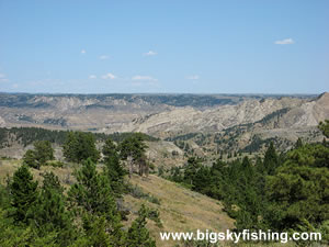
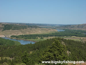
Highlights of the trip include passing through the remote and rugged Missouri Breaks region of Montana, the Missouri River, and just a plain unique drive in a remote and very scenic part of Montana that few people even know about – let alone visit. In short, by doing this Byway, a person comes away with bragging rights!
Important Note - If you plan to drive this route, contact the BLM Lewistown office to inquire about road availability. At times, including in 2016 when I last visited, part of the road was closed due to the road "sliding out" and giving way. You can contact the Lewistown office at:
- Bureau of Land Management
- Lewistown Field Office
- 920 NE Main
- Lewistown, MT 59457
- Phone: (406) 538-1900
Before beginning a detailed description of this drive, I need to present some words of caution and education for those planning a trip down the Missouri Breaks National Backcountry Byway.
First, every single web site I’ve visited that provides information about this drive, with the exception of the sparse information provided on the BLM web site, is incorrect. The reason all these other web sites have incorrect information is because they copy the incorrect information from one site to another. In short, the people who have put together information about the Missouri Breaks National Backcountry Byway on their web sites have never driven this route and have no clue about it. Therefore, the moral of the story is this – do not trust what other web sites (including, I might add, the State of Montana’s web site) say about this drive!
Secondly, the Missouri Breaks Backcountry Byway is the lone route shown in the scenic drive section of the Big Sky Fishing that requires four-wheel drive to complete it. For most of the Byways length, during dry summer weather, even two-wheel drive vehicles will have few problems beyond dodging deep ruts that threaten to tear out the bottom of the vehicle. However, there is a short stretch of the Byway where having four-wheel drive is essential, especially if you’re driving east toward Kipp Recreation Area. Thus, if you want to drive the entire Byway between Winifred and Highway 191, you will need four-wheel drive even during the summer.
Finally, I also need to clear up some of the misinformation seen online about the length and direction of the Byway. The “official national byway” is not a loop. Instead, the official byway runs between Winifred, Montana, and the junction with Knox Ridge Road that is located about ten miles to the west of Highway 191. The length of the designated national backcountry byway is about 39 miles. Travelers can create a loop by following the rather boring Knox Ridge Road back to Winifred. But for clarity sake, it needs to be remembered that the “loop” part often read about online is not part of the official Missouri Breaks National Backcountry Byway. Instead, it’s just a convenient option that I don’t recommend doing.
Now, with all that out of the way, let’s get into the description of the Byway. We’ll start at the western beginning point of the Missouri Breaks National Backcountry Byway, near Winifred.
Technically speaking, the designated portion of the Byway does not begin in Winifred. Indeed, when visiting Winifred, there’s not a single sign that even mentions the Byway at all. Fortunately, finding the Byway is easy. From “downtown Winifred” on Highway 236, there’s only one road that goes “to the east,” the D-Y Trail. The D-Y trail is an all-season gravel road.
After two miles, the road reaches an intersection. At the junction, you’ll want to go to the right, since the road that veers to the left leads to the ferry across the Missouri River. It is at this intersection that the “official” byway begins.
Continued on Next Page 1 | 2 | 3
Map of the Missouri Breaks National Backcountry Byway
The map below shows the route and location of the Missouri Breaks National Backcountry Byway in Central Montana.

|
Related Articles & Information
|
Copyright 2002 - 2026 Big Sky Fishing.Com
|
|
|