The Missouri Breaks National Backcountry Byway, Page 3
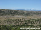
Once the Missouri Breaks Backcountry Byway reaches the top of the ridge that overlooks the valley, the road meanders through the Missouri Breaks region for a few more miles before reaching the junction with the Knox Ridge Road (at mile 39).
The “official” Missouri Breaks National Backcountry Byway ends at this intersection. Travelers then have a choice. They can either turn right (west) to make a “loop” back to Winifred. Alternatively, travelers can take the much more scenic route to the east, toward the Kipp Recreation Area and Highway 191.
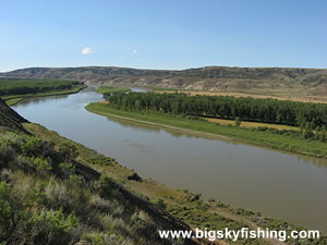
Continuing east toward Highway 191 from the Knox Ridge Road junction, the remaining nine-miles of the drive twists and turns along the top of the ridge, providing excellent views of the Missouri River and the surrounding Missouri Breaks region. This nine-mile stretch is, in my opinion, the most scenic of the entire drive. The road itself on this nine-mile stretch is dirt, and full of tight turns. However, since eastbound travelers are heading downhill, there should be no issues or worries about being stuck. When the road is dry, even two-wheel drive vehicles can drive this stretch.
The drive ends at the junction with Highway 191. The James Kipp Recreation Area is right across the road, and makes a perfect spot to camp.
Overall, the Missouri Breaks Backcountry Byway is a spectacular trip through the remote, rugged and rarely visited Missouri Breaks region of Montana. Anyone with a taste for adventure, and a four-wheel drive vehicle, should find the time to make the trip. Although the Byway is located far away from the main highways tourists to Montana use, the “detour” to reach the Missouri Breaks region of Montana is well-worth it.
Quick Facts
- Length: 47 miles (one-way length between Winifred and Kipp Recreation Area). The 'official length' of the road is 39 miles. Or a loop (using Knox Ridge Rd.) can be made that is about 80 miles long.
- Highlights : The remote Missouri Breaks region of Montana, the Missouri River
- Road Type : Gravel and dirt
- Nearby Towns : Winifred, Lewistown
- 4wd needed? : Yes (to complete the full drive)
- Traffic : Virtually none
- Trailers? : No
- Season : Impassable during wet weather or during the mud season. During wet weather or the mud season, ride a horse instead.
Previous Pages 1 | 2 | 3
Map of the Missouri Breaks National Backcountry Byway
The map below shows the route and location of the Missouri Breaks National Backcountry Byway in Central Montana.

|
Related Articles & Information
|
|