Location Highlights of Butte, Montana
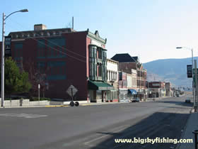
Butte lies in southwest Montana, along Interstate 15 and Interstate 90. It’s about a 2-hour drive to the Idaho border to the south down Interstate 15. Likewise, Missoula is about a 2-hour drive to the west down Interstate 90. Helena, the state capitol, is about 80 miles to the north along Interstate 15. Perhaps not unexpectedly, the convergence of the Interstate 15 and 90 has brought some growth to Butte, in the form of hotels, truck stops and other things that cater to traveling motorists.
The location of Butte is both beautiful and, well, rather ugly, all at the same time. On the good side, Butte is located right on the western edge of the Continental Divide in Montana. Granted, the mountains that form this portion of the Continental Divide here are not that tall (not rising above 9000 feet). Still, the Continental Divide, in combination with several other taller, nearby mountain ranges (the Anaconda-Pintlar Range is about 20 miles to the west) do provide a nice, scenic backdrop for Butte.
The whole area itself is also a nice mix of open fields and wooded hills. As such, many various outdoor activities are available around Butte – from 4x4’ing, hiking, hunting and yes, even fishing now that the nearby rivers have been cleaned up.
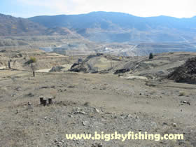
Yet, detracting from this otherwise scenic area are two ugly scars that won’t be disappearing anytime soon. First, the legacy of 50 years of active strip mining is seen from everywhere. These strip mines essentially took apart a small mountain/large hill. These strip mines, in combination with the “small wasteland” that surrounds some of the old mining rigs in around town (particularly in Upper Butte), detract from the view in Butte.
The other big detraction of the area occurs just down the road, near Anaconda. Here is where the heart of the Sueprfund Site is, a vast swath of old mining tailings with either little or no soil. The whole valley around Anaconda is essentially a previous wasteland that is only now beginning to recover (with grass and small trees now beginning to grow in the cleaned up spots). Granted, the area has recovered remarkably well from where it was back in the 1960’s and 1970’s (when it was a true wasteland in every sense of the word, according to my Mom who lived around here in the late 1960’s). But, it still has a long way to go – and is certainly no match for the scenic valleys found elsewhere in Montana that do not have centuries old mining scars to contend with.
Butte has used this environmental cleanup to create some parks and bikeways. Just down the hill from Uptown Butte is Silver Bow Creek, which is part of the Superfund Site. To clean it up, numerous settling ponds were built to trap the metals – preventing them from being washed downstream. Not only has this worked remarkably well in cleaning up the Clark Fork further downstream, it allowed Butte to create some nice walking and biking trails around these tailing ponds. Several small park areas also were built.
Unfortunately, beyond these parks, Butte is sadly lacking in open areas. While there is no shortage of open space just outside of Butte, the town itself has a lacking of established and developed parks. Thus, if you plan to visit Butte and want to have a picnic lunch at a nice park, don’t plan on doing it in town. While the handful of parks Butte does have are decent, the town just doesn’t have enough of them for a city of its size – with most of their parks also being tucked away in hard to find spots of town.
Next Page : More Information About Butte
Related Articles
Web Resources
|
Copyright 2002 - 2018 Big Sky Fishing.Com
|
|
|