The Smith River Region Backcountry Drive
The Smith River Region Backcountry Drive, as the name suggests, takes visitors through the heart of the remote Smith River region of Montana. This seldom-visited part of Montana consists of a mixture of expansive prairie, scattered prairie, low elevation arid plains and forested mountains.
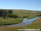
The drive itself runs between Interstate 15, at Ulm, to White Sulphur Springs. Highlights of the journey include the Smith River and an enjoyable trip through a very remote part of Montana that few people ever see.
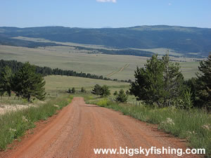
The Smith River Region Backcountry Drive, with a length of ninety-two miles, is not a short journey. About thirty-three miles of the drive is paved, with the remainder utilizing various all-season gravel roads that, although often dusty, are wide and in good condition. During the summer months, a normal passenger car will not have problems traveling down this route except during periods of wet weather.
Beginning in Ulm, at the junction with Interstate 15, the scenic drive follows Montana Highway 330. On some maps, this road goes by the name Millegan Road. The drive follows the paved highway for seventeen miles, closely following the Smith River for much of this distance. Several fishing access site are also along this section of the drive, although the best trout fishing is found further up-stream.
After seventeen miles, the road reaches the junction with Boston Coulee Road. This road leads to the Eden Bridge Fishing Access Site on the Smith River, which is the most popular take-out spot for float trips down the Smith River.
The drive continues to follow the paved highway for another two miles before reaching another road junction. Millegan Road continues straight, toward Cascade, while the Smith River Region Backcountry Drive goes left (south) at the road junction, following the gravel Upper Millegan Road.
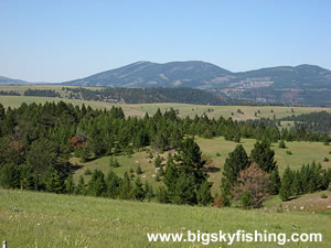
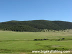
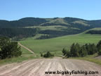
After climbing a short but steep hill that provides a nice view of a small agricultural valley, the countryside opens up as the road essentially crosses a vast, rolling plateau while hopping between a series of different, unnamed valleys. The terrain is primarily prairie and grass, with scattered forests, while the forested mountains of the Little Belt Mountains rise to the east.
For the next forty miles, the Smith River Region Backcountry Drive rolls through this remote and empty part of Montana. The views seemingly change at the top of every hill and around every corner. Although the Little Belt Mountains aren’t the most dominating of mountain ranges in Montana, they provide a very scenic backdrop to this most enjoyable section of the drive.
During this stretch of the drive, there are few other roads. Thus, it’s difficult to get lost or turned around. However, the road junctions that exist are not marked in any way. Because of this, it’s essential to stay on the roads that seem in the “best condition.” Use common sense and, better yet, carry with you a topographical map book to help you decipher these intersections.
The gravel portion of the drive ends after seventy-three miles. A few miles later, the Camp Baker Road cuts off to the left toward the Camp Baker Fishing Access Site, which is where virtually all float-parties on the Smith River put-in. The drive ends at White Sulphur Springs, at the junction with US Highway 12.
Overall, the Smith River Region Backcountry Drive in Central Montana is a trip well worth doing. While the portion of the drive just south of Ulm and just outside of White Sulphur Springs isn’t the most fabulous part of Montana, the middle section of the drive takes visitors through a beautiful landscape of fields, prairie, forest and mountains.
Quick Facts
- Length: 92 miles
- Highlights : Smith River, the remote Smith River region of Montana
- Road Type : Primarily Gravel
- Nearby Towns : Ulm, Cascade, White Sulphur Springs, Great Falls
- 4wd needed? : No, except when gravel portion of road is snow-covered, very wet or muddy
- Traffic : Light
- Trailers? : Yes
- Season : Year-round, weather conditions permitting
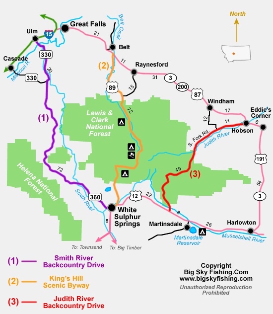
Map of the Smith River Region Backcountry Drive
The map below shows the route and location of the Smith River Region Backcountry Drive in Central Montana, along with the locations of other nearby scenic drives.
|
Where to Stay & Other Services
There are no services or lodging along the route. White Sulphur Springs, Ulm and Great Falls are where gas and other supplies should be otained.
There are no designated campgrounds along the scenic drive. However, as the drive passes through large swaths of land owned by the BLM, primtive camping can be done in many spots.
For lodging, White Sulphur Springs has several small, privately owned motels. Great Falls, though, has by far the largest selection of lodging options.
|
Related Articles & Information
|
|