
The Clark Fork begins at the confluence of Silver Bow Creek and Warm Springs Creek in the Warm Springs Wildlife Management Area, located west of Butte and east of Deer Lodge.
The fact that this river has any fish at all is a surprise to many anglers. After all, the Clark Fork has the dubious honor of originating near the largest Superfund site in the US.
Silver Bow Creek near its headwaters is essentially fish-less, as various toxic metals are found in and all along the creek just upstream from its confluence with Warm Springs Creek. These toxins once drained into the Clark Fork and caused the Clark Fork tremendous environmental damage.
But many years of extensive cleanup has turned the Clark Fork into an excellent river for trout fishing and recreational river floating.
Table of Contents
- Clark Fork – General Overview
- Fishing the Clark Fork – Introduction & General Overview
- Fishing the Upper Clark Fork
- Fishing the Middle Clark Fork
- Fishing the Lower Clark Fork
- Floating & Paddling the Clark Fork
Related Article – Clark Fork Photographs
The Clark Fork : General Overview
The Clark Fork is one of the longest rivers in Montana, stretching more than 280 miles from its origin to the Idaho border. The last sixty miles of the river is essentially a series of lakes created by three dams. The best fishing on the river is found between its origin and the confluence with the Flathead River near Paradise.
For its entire length in Montana, Interstate 90 roughly parallels the river, providing frequent if sometimes noisy access sites. The terrain the Clark Fork flows through is quite diverse. At its origin, large, arid plains mark the area with towering mountains located to the south. The many scars on the landscape, especially near its headwaters, serve as a reminder to historical mining activity. The Clark Fork picks up flows from many smaller streams as well as the Little Blackfoot River in this section.
The Clark For near Drummond, Montana
Further downstream, beginning around Drummond and lasting until Missoula, the river picks up additional volume from small feeder streams. The river then starts to thread its way through the Garnet Range on the north and the John Long Mountains and Sapphire Mountains to the south. In this section, the riverbanks are frequently forested and it is quite scenic.
The valley the river flows through in this section is quite narrow, and mountains frequently abut right against the river. Despite this narrow valley, access to the river is excellent. A road closely follows the river on the north side for much of the distance in the canyon, allowing for easy off the road access. Several bridge crossings and designated fishing access sites provide further access. The Clark Fork picks up the flows from Rock Creek, Flint Creek and the Blackfoot River in this canyon section as well.
The river leaves the mountains temporarily and enters Missoula, Montana. Downstream from Missoula, the river picks up the flows from the Bitterroot River and makes its way through a fairly large plain before entering heavily forested mountains another twenty miles downstream.
This is a very scenic area, with moderately tall, heavily forested mountains rising above the river. While the Interstate roughly parallels the river, the Clark Fork is generally located deep down in a canyon, usually a hundred feet or more below the level of the road. The only real whitewater on the Clark Fork is also encountered in this section. A number of designated fishing sites, along with many road access spots, provide decent access to the river.
After flowing through this scenic countryside for another sixty miles, the Clark Fork joins up with the Flathead River, and becomes a sizable river. While the countryside is still mountainous, the area is noticeably drier and not nearly as forested as found just a bit upstream.
Following its confluence with the Flathead River, access to the Clark Fork becomes more difficult, with only a handful of fishing access sites providing access to the river. The river continues on to a series of dams downstream from Thompson Falls, Montana.
Fishing the Clark Fork – Introduction & Overview
That the Clark Fork has any fly fishing at all, let alone very good fishing sections in spots, is a testament to the ability of nature to overcome total man-made environmental debacles and provides a showcase of how to go about cleaning it up.
Not so long ago the Clark Fork would often run red, full of heavy metals and mining wastes that flowed down the entire length of the river, killing all but a handful of lucky fish. These mining wastes originated near the headwaters of the Clark Fork, in the heavy mining area surrounding Butte, Anaconda and Opportunity. These wastes ended up in the two primary feeder creeks that create the Clark Fork, Warm Springs Creek and Silver Bow Creek.
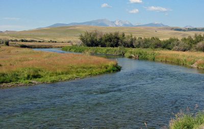
This is the Upper Clark For, about 15 or so miles downstream from its origin. The banks are still bushy, but it’s beginning to “open up.”
With the creation of the Superfund Act, a huge section of the Clark Fork was declared a Superfund Site and much money and time has gone into cleanup. The Anaconda Settling Ponds were created and engineered to catch the mining wastes before they entered the headwaters and have been very effective at trapping the heavy metals. So effective, in fact, that virtually all of the heavy metals that come down from various feeder creeks (Silver Bow Creek and Warm Springs Creek in particular) are kept out of the Clark Fork.
As a result of these efforts, the Clark Fork has been making a solid recovery and now plays hosts to lots of large brown trout and rainbow trout. Excellent fly fishing is found in numerous spots along the Clark Fork, some of which rival that found on other more notable rivers (many of which drain into the Clark Fork, such as the Bitterroot, Blackfoot and Rock Creek). While the entire Clark Fork holds trout, the best fishing is found in various spots along the river. A successful angler will bypass slower area and instead focus on the best producing water.
The Clark Fork is a long river and flows for more than 300 miles in Montana. The lower sixty miles consist of a chain of dams and reservoirs. The remainder of the Clark Fork, though, holds every kind of habitat a fly fisherman could want. Whitewater, pools, runs, riffles, brushy banks, grassy banks, forested banks, fast current, slow current and much else await an angler visiting the Clark Fork.
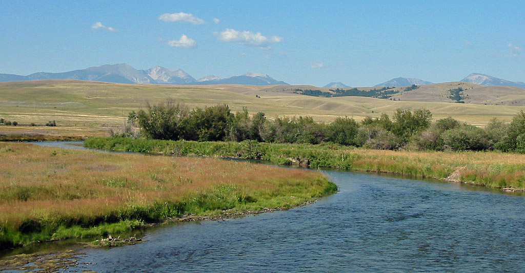
An angler visiting the Clark Fork for the first time and sees the river at its origin and later downstream can only be amused by the changes in the river. At its origin in the Warm Springs Wildlife Management Area, the Clark Fork is so narrow most people could jump across it.
Yet the river picks up flows from numerous feeder streams and by the time it reaches Deer Lodge it is a sizeable river. By the time the Clark Fork flows through Missoula it is a very large river. And after it picks up the flows of the Flathead River near Plains it becomes a massive river—the biggest river in the state, in fact.
Thus, an angler who plans on fly fishing the Clark Fork for the first time should think about what type of river they like to fish. If you enjoy fly fishing in a small river setting, don’t plan on fishing below Missoula. Likewise, if a spring creek fishing experience is what you are looking for, plan on fly fishing near the origin. And if float fishing is your style, plan to fish downstream from Missoula.
In short, the Clark Fork offers enough fly fishing variety to satisfy any angler. It provides excellent fishing in spots, and both very large brown trout and monster rainbow trout have been pulled from the river. And as an additional benefit, compared to other Montana rivers, fishing pressure on the Clark Fork is generally light. With its nasty reputation and its close proximity to more notable trout rivers, most anglers drive right by the Clark Fork without a second thought. As a result, many sections of the Clark Fork allow anglers and floaters to have the river to themselves.
Fishing the Upper Clark Fork
Origin to Galen
From it’s beginning in Warm Springs Wildlife Management Area to Galen, the Clark Fork resembles a spring creek. Directly at its origin, the Clark Fork is incredibly narrow, thickly choked in brush, twists and turns extensively (like every 5 yards there is another turn) and is quite shallow.
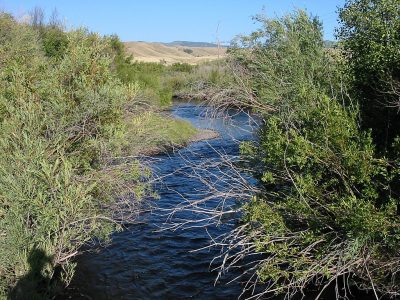
The Upper Clark Fork, just downstream from the Anaconda settling ponds, is very narrow and bushy
The first five miles of the river flow in the Wildlife Management Area and thus have special fishing restrictions. Once it leaves the Wildlife Management Area the Clark Fork gradually picks up some flows and some width and by the time it reaches Galen resembles a “large” spring creek rather than the tiny creek found further upstream. Regardless of where you fly fish on this section, come prepared for spring creek fishing with all that accompanies it—the brown trout are wary, the casting is difficult and a careful approach is mandatory.
This is brown trout country, although an occasional rainbow trout is found (they end up here by flowing down through the spillways in the Anaconda Settling Ponds). The brown trout average around 14 inches, with an occasional trout exceeding 20 inches. There is a sizable fish population along this section of the Clark Fork; estimates put the population in excess of 1500 per mile. Considering the tiny size of the river—not to mention its proximity to the environmental disaster found just upstream—the high fish population is quite remarkable.
Fishing pressure on this section of the Clark Fork is not abnormally heavy. That said, most anglers fish at or near one of the three bridge crossings. A short walk up or downstream (not always easy due to the thick brush in and around the river) allows an angler to fish waters that seldom see a fly line.
Catching the brown trout on this section of the Clark Fork is no easy task. Besides having to quietly wade through a spring creek and fight the overhanging brush on the riverbanks, good fly imitations and presentation are very important.
Before the height of spring run-off occurs, Cranefly imitations can work well. These insects end up in the river due to the rising levels of the river. Other early season dry flies that are effective include the Elk Hair Caddis, the Parachute Adams, and the X-Caddis, sized 14-16. Effective early season nymphs are the Hare’s Ear Nymph and the Pheasant Tail Nymph, in sizes 14-18.
Spring run-off generally occurs in May and can last through late June, depending on the vagaries of the weather. Once spring-run off begins to subside, a locally developed dry fly, the Emergent Sparkle Pupa, works extremely well. This fly was specifically developed for the Clark Fork. Additionally, a standard Elk Hair Caddis or X-Caddis also are effective just after run-off ends.
Beginning in July and lasting through September, hopper imitations become extremely effective. Hoppers are found everywhere along the Clark Fork and should you forget this before arriving you will be quickly reminded of it after taking a short walk through the fields that border the Clark Fork. Your vehicle will also be covered in hoppers, generally requiring a trip to the local car wash to “repair” the damage. Other popular dry flies, such as the Parachute Adams and the PMD Cripple, are also effective. For the angler who enjoys fly fishing nymphs, the Hare’s Ear Nymph and the Pheasant Tail Nymph also work well.
Although this is brown trout water, streamers aren’t heavily used on this section of the Clark Fork during the summer. Few baitfish (such as whitefish or sculpins) are found in the upper Clark Fork. As a result, the brown trout feed almost exclusively on insects and are less than apt to tackle a large streamer pattern—especially considering the vast array of insects that are found on the upper Clark Fork (this section of the Clark Fork runs through a very fertile valley).
This changes, though, beginning in the fall. Large streamers, such as the Muddler Minnow and the Marabou Muddler, work excellent in pulling the brown trout—now more aggressive than earlier in the season—out from their holes and hiding places. And there is no shortage of places to fish these streamers. This section of the Clark Fork has some habitat for brown trout, although it is frustrating at times casting to them due to the brush and the rivers narrow width.
Overall, this short section of the Clark Fork has been tailored made for the fly fisherman who enjoys spring creek type fishing conditions. The extensive brush, the twists and turns or the river and its narrow width all combine to create classic spring creek fishing conditions. Just be prepared for some casting difficulties since all the brush makes casting difficult at times.
Galen to Deer Lodge
In this section of the Clark Fork, the river turns from a large spring creek to a small river by the time it reaches Deer Lodge. Unlike further upstream, irrigation use of the river is heavy, leaving the river with low flows and warm temperatures later in the summer. Habitat degradation in the form of cattle grazing along the banks to numerous irrigation developments all take a toll on the fly fishing. As a result, brown trout numbers begin to decline from Galen downstream to Deer Lodge.
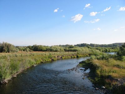
The Clark Fork near Kohr’s Bend Fishing Access Site, near Drummond
In the upper part of this section, the Clark Fork can still have extensive brush along its banks. The brush, though, soon gives way to more open banks of hay and fields. As a result, the fishing conditions are easier than found upstream near the origin. Casting is generally not a problem since the river is wider and wading is easier since you don’t have to fight a jungle of prickly undergrowth.
While trout populations decline downstream from Galen, the populations are still healthy. The brown trout are also quite large, averaging more than 14 inches, with the occasional 20+ inch trout being seen from time to time.
Fly fishing for the brown trout here is similar to found upstream. More baitfish are located in this section of the Clark Fork, however, allowing streamers to be fished successfully all summer long. As is found further upstream, excellent habitat for the brown trout exists, with countless holes, undercut banks and downfalls providing wonderful cover.
Access to this section of the Clark Fork is good. While no designated fishing access sites exist, many county road bridge crossings are available which provide good access.
Overall, while this section of river may not have the high density of brown trout populations as found upstream, the easier fishing and casting can make for an easier experience for those lacking precise casting skills. And since the river is still fairly narrow and not too deep, wade fishing this section of river is relatively easy.
Fishing the Middle Clark Fork
Deer Lodge to Drummond
Brown trout populations continue to decline in this part of the Clark Fork, due to both warm water temperatures, low water in the summer and the thinning out of good habitat for brown trout (some stretches of this section may hold no trout at all due to lack of habitat).
Both the Little Blackfoot River (in Garrison) and Flint Creek (in Drummond) empty into the Clark Fork, providing additional flows and much needed water later in the summer. The best fly fishing on this river section happens between Garrison and Deer Lodge, as fish populations continue to thin out the further downstream one travels.
With that said, this section of the Clark Fork is home to the largest brown trout in the river. Fly fishing with streamers and large nymphs are the most popular and effective methods of catching these fish. Streamers are fished deep in the holes and around other obvious brown trout habitat. Popular streamer patterns include the Muddler Minnow and the Marabou Muddler.
Fishing with large nymphs is also effective on this section. Popular nymph patterns include the Prince Nymph, the Hare’s Ear Nymph and Wolly Buggers, in sizes 4-10. The nymphs are best fished dead drifted, weighted down if necessary to get into the deeper holes.
Access to this section of river is fair. Other than a nice fishing access site at Kohrs Bend, access is limited to a handful of road crossings. Additionally, the Interstate generally closely follows the river in this section, creating a rather noisy environment.
Drummond to Clinton
This section of the Clark Fork is home to few fish. Irrigation use on this section is quite heavy, and by late summer the water warms up well into the upper 70’s—a temperature not conducive to good trout fishing. The only real time to fish this section is during the fall when some large brown trout make spawning runs.
And this is unfortunate since this is one of the prettiest sections on the Clark Fork. Just downstream from Drummond the Clark Fork starts to slice its way through the mountains, with many open fields along its side. While the fly fishing in this section may not be anything special, a float trip through this area is a beautiful one—especially in the fall when all the hardwood trees lining the rivers banks turn colors.
Access is also fairly good. While no designated fishing access sites exist, a county road parallels the river on the north side for much of its length. A small boat or canoe can easily be slid down the banks. A trip up to Garnet Ghost Town is also a worthy diversion, too.
Clinton to Missoula
At the small town of Clinton the Rock Creek joins the Clark Fork, adding substantially to its flows. The cool water of Rock Creek also substantially lowers the rivers temperature. A few miles further downstream the Blackfoot River then empties into the Clark Fork, once again adding additional flows with cooler water temperatures. The result is that this section of river has excellent fly fishing for rainbow trout and brown trout, along with some cutthroat trout.
The Clark Fork in this section continues to slice its way through the mountains, with tall and forested mountains rising right up from the rivers edge. The river starts to become fairly sizable (in both width and depth) in this section and wading across the entire river is generally not possible except during the lowest of water. The river has many riffles and runs in this section, too, providing a nice mix of water to fish.
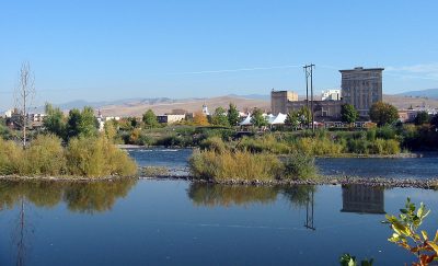
Clark Fork as it Passes Through Missoula, Montana
Fishing this section of river begins in late May with the Salmonfly hatch. Depending on spring run-off and water conditions, this hatch can produce some wonderful fishing or be a bust due to cloudy water. If the water is clear, though, excellent fly fishing using Salmonfly imitations such as the Brooks Stone and Kaufmanns Stone, in sizes 2-6, occurs.
Beginning in the middle of June and lasting through July, depending on the state of spring run-off on the Clark Fork, a good Green Drake and Brown Drake hatch occurs. Popular and effective flies for this hatch include Green Drake Emerger and the Olive Sparkle Dun (sizes 12-16) for dry fly fishing and the Hare’s Ear Nymph (size 12-16) for nymph fishing.
Late June and July also provides an excellent time to use Stonefly imitations, such as the Montana Nymph and the Golden Stone Nymph (sizes 4-10).
By the time mid-July rolls around, this section of the Clark Fork becomes, surprise, a great hopper fishing water that lasts through September in most years. Standard hopper imitations in sizes 4-10 work well. If the current keeps attempting to suck your fly down, apply a liberal coat of floatant on the fly.
In the fall, similar to that found further upstream, streamers come into play and are equally effective catching both the large brown trout as well as the large rainbow trout that are found in the river. Throw the streamers into the holes and around other attractive habitat.
Access to this section of the Clark Fork is good. Several designated fishing access sites exist, and a few informal access areas are also found at various bridge crossings. For the more adventurous, an abandoned railroad bed closely follows the river in some stretches. If you don’t mind the risk of trespassing (who owns this land anymore I have no idea!), a wade angler can reach areas few wade anglers ever visit.
Downstream to Missoula, the Clark Fork is heavily used for recreational floating during the summer—particularly on weekends. If you’re looking for a float more in solitude, consider rafting further upstream or downstream.
Fishing the Lower Clark Fork (Missoula to Thompson Falls)
The Clark Fork enters the Bitterroot Valley at Missoula and flows through the valley for some twenty miles before it enters the mountains again.
Once it enters the mountains, the Clark Fork flows through a beautiful landscape of small mountains with thick forests. As the river travels further downstream, the forests gradually thin out, with more rock found along the rivers edge–particularly downstream from St. Regis, Montana.
The Clark Fork picks up the flows from the Flathead River at Paradise and becomes a massive river. The foliage along the river continues to thin out and the mountains get smaller as the river continues on towards Thompson Falls and the several reservoirs the Clark Fork flows into.
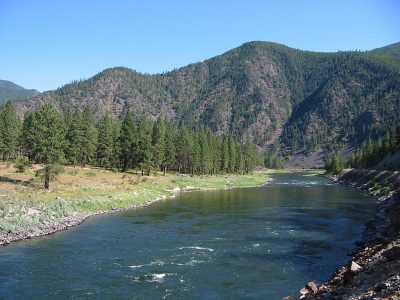
Lower Clark Fork Beneath St. Regis, Montana
The Lower Clark Fork picks up the flows from several major rivers and many smaller ones, including the Bitterroot River, the St. Regis River and the Flathead River.
By the time the river leaves the Bitterroot Valley, the Clark Fork is a very large river with solid current and lots of depth. Below Paradise, the river is a huge river, and ranks as the largest river in the state. As a result, float fishing is the best way to fish the lower river. Wade anglers are at a big disadvantage since so many good fishing spots on the river are not accessible by foot.
Considering the rivers size and how sizable its drainage is, it is somewhat surprising that the river remains quite clear. Except for during the height of spring run-off, the Lower Clark Fork runs clear throughout the year.
Fishing pressure on the Lower Clark Fork ranges from low to moderate, depending on where you are. The heaviest pressure happens in and around Missoula. The further downstream one travels, the less fishing pressure is found. Just be aware that many recreational floaters use the river, especially between Petty Creek Fishing Access Site and Tarkio Access Site due to some wild whitewater in that section.
Access to the Lower Clark Fork is generally quite good. A number of fishing access sites are along the river between Missoula and St. Regis. Between St. Regis and Paradise, a highway closely follows the road, providing nearly unlimited access. Downstream from Paradise to Thompson Falls, access to the Clark Fork dries up considerably and is limited to a handful of bridge crossings.
Fish populations on the entire Lower Clark Fork are lower than found further upstream. Rainbow trout are the prime fish found in this section of the Clark Fork. And while their numbers may not be large (less than 1000 per mile – not a high number considering the size of the river in this section), the fish can get extremely big—sometimes exceeding 30 inches.
Early season fly fishing on the Lower Clark Fork can begin as early as April during the Skwala stonefly hatch. A popular and effective fly for this hatch is the Olive Stimulator, fished down deep. Just beware of the Montana weather during this time. It may range from sun, rain, ice or snow – or with some combination of the above.
Late April or early May generally sees the onset of spring run-off, blowing out fishing. Spring run-off generally ends by late June, which coincides with a solid Gray Drake, and Pale Morning Dun hatch. Effective dry flies during this time include the Parachute Adams, the Sparkle Dun, the Comparadun, the Light Cahill and the Elk Hair Caddis, in sizes ranging from 10-18. Effective nymph imitations include the Hare’s Ear Nymph and the Pheasant Tail Nymph, in sizes 12-16.
Beginning in mid-July and lasting through September, grasshopper imitations also work extremely well, and are often the best choice since they are effective when other hatches are occurring. Hopper imitations provide a good alternative for the angler who can’t match the hatch.
Fall on the Lower Clark Fork has a solid Baetis hatch. Popular flies for this time period include the Parachute Adams, the Sparkle Dun and the Hare’s Ear Nymph, in sizes 14-20.
When fly fishing on the Lower Clark Fork, remember that fishing is spotty. This is a big river with relatively low populations of fish per mile. When fly fishing the Lower Clark Fork, pass on unproductive water and focus on select areas.
In particular, look for top water activity and concentrate your fishing there. It is not unusual for pockets of fish to be separated by several hundred yards of empty water. Should top water activity not provide any evidence of where the fish are, look for seams in the current. These seams develop due to variable current speeds—usually faster in the middle of the river and slower near the shore. Fish frequently hold right at this seam. A dry fly or nymph floated right on the edge will frequently find the fish.
In addition to providing excellent, if somewhat scattered, trout fishing, the Lower Clark Fork, below Plains, also provides excellent pike fishing. Many of the pike found in the Lower Clark Fork exceed twenty-pounds. Since the river is so large below Plains, many anglers use motorboats to reach the productive areas of the river.
Petty Creek Access to Tarkio Access Site
An exception to the spotty fly fishing on the Lower Clark Fork occurs on the whitewater section between Petty Creek Fishing Access Site and Tarkio Access Site. In this section of the river, extensive whitewater, often up to Class IV, exists. Trout populations in this section are significantly higher than elsewhere in the Lower Clark Fork. The problem, of course, is reaching them.
This section of the Clark Fork is exceedingly difficult to reach by foot except by a long walk upstream from the Tarkio Access Site. Floating is not much easier, though, due to the fast current, waves, and whitewater. Trout are found holding behind the large rocks in the river, in the deep pools and other good habitat in this section. The trout in this section are also quite large, often exceeding twenty inches. Streamers are the most effective way to catch these fish, using a sinking line with weights in order to get the flies down to depth.
Clark Fork – River and Fishing Summary
Overall, the Clark Fork is a beautiful river that offers superb fly fishing for large trout. While the fishing is scattered and the size of the river can be intimidating, the combination of being able to take large trout in a beautiful setting makes fly fishing on the river an enjoyable time.
The future of the Clark Fork is a bright one, hopefully. While other environmental horrors may await the Clark Fork due to past mining activities, and extensive irrigation use does hamper fly fishing in some sections, an EPA plan calls for a massive removal of sediment along the river and the creation of a “buffer zone” along most of the rivers length, among other things. This plan, if ever implemented, promises to go along way in turning the Clark Fork into a true blue-ribbon trout stream.
Floating & Paddling the Clark Fork
The Clark Fork in Montana has a somewhat nasty reputation among most anglers and floaters due to its past and continuing environmental problems. As a result, fishing and floating pressure for most of its length is fairly light in comparison to other prime Montana rivers.
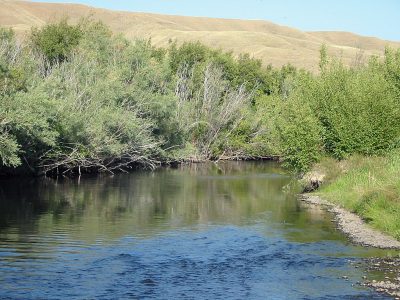
The Upper Clark Fork River, near it’s origin in Warm Springs
Floating or rafting the Clark Fork can begin as far up as its origin, in the Warm Springs Wildlife Management Area, although the section between its origin and Garrison has fairly slow water. The river also resembles more of a spring creek than a river for its first twenty miles.
As a result, only very small inflatable rafts, inflatable kayaks (the best bet) or canoes will work well when floating from the headwaters. Anyone who plans to float between its origin and Galen should expect portages around obstructions, lots of overhanging brush and some general frustrations in general. It is not an easy float. Below Galen, the Clark Fork becomes friendlier to floating during normal water levels.
Upstream from Deer Lodge, Montana, the Clark Fork gradually picks up flows until it begins to resemble a decent sized river, albeit frequently a shallow one due to irrigation use. Later in the summer, this part of the Clark Fork may be unfloatable due to heavy irrigation use, so be sure to check river flows.
Downstream from Deer Lodge, at Garrison, the Little Blackfoot River empties into the Clark Fork, increasing flows and providing for solid and consistent rafting conditions year round.
Below Drummond, pressure on the river increases as more float parties use the river for fishing and pleasure. Access sites between Drummond and Milltown Dam are somewhat sparse and widely spaced apart. However, by using the road on the north side of the Clark Fork, float parties using smaller boats can easily drag their boats down the banks and plop them in the river. Inflatable rafts, inflatable kayaks and canoes are the best boats for this—disaster likely awaits any floater trying this with a drift boat or larger fishing raft.
Twenty-five miles below Drummond and just above the Beavertail Hill access site, a diversion dam must be portaged.
The river continues flowing through the forested canyon below the diversion dam, picking up the waters of Rock Creek ten miles downstream from the diversion dam. It then picks up the flows of the Blackfoot River another fifteen miles further downstream.
Downstream from the Blackfoot River confluence, the river soon begins to make its way through Missoula and the Bitterroot Valley. The Clark Fork divides into two channels in Missoula. To avoid a diversion dam and a portage, use the left channel.
Below Missoula, the river continues another 35 miles with somewhat sparse access to Alberton, where the first significant whitewater on the river begins. Between Alberton and the Tarkio Access Site, a distance of sixteen miles, the river has many whitewater sections. Depending on river flows, the whitewater can hit Class IV difficulty. In general, the higher the flows the more difficult the rapids are, so check current river flows before rafting this stretch of river.
Canoes are not recommended on this section of river, and only intermediates and above should take rafts or inflatable kayaks down this section of the Clark Fork. During sunny weekend days, this section of the Clark Fork receives heavy use from recreational floaters, with theTarkio Access Site (the popular takeout spot) resembling controlled chaos.
Following this stretch of whitewater, the Clark Fork continues for another thirty miles until its confluence with the St. Regis River, where the Clark Fork leaves the Interstate behind. This section of the Clark Fork offers a very scenic float for thirty-five miles to the town of Plains. One stretch of whitewater exists, depending on river flows, 18 miles downstream from the St. Regis River confluence.
Five miles downstream from Plains, the river has a short Class II and a Class III rapid. Below these small rapids, the river continues to Thompson Falls. Floating essentially ceases at Thompson Falls, as several dams back up the river and form a chain of lakes to the Idaho border.
Selected River Miles for the Clark Fork
Listed below are selected river miles for the Clark Fork in Montana. Visit the Montana FWP website for more information about a specific fishing access site (FAS).
- Origin (Warm Springs and Silver Bow Creeks): 333
- Kohrs Bend FAS: 304.1
- Drummond FAS: 273.4
- Beavertail Hill State Park: 245.2
- Rock Creek Confluence: 238
- Schwartz Creek FAS: 235.8
- Turah FAS: 227.7
- Sha-Ron FAS: 219.1
- Kelly Island FAS: 208.5
- Council Grove State Park: 202.8
- Erskine FAS: 190.4
- Petty Creek FAS: 177.5
- St. Johns FAS: 171.8
- Cyr Bridge FAS: 169.5
- Tarkio FAS: 159.9
- Forest Grove FAS: 154.8
- Big Eddy FAS: 143.1
- St. Regis FAS: 127.9
- Mackay Landing FAS: 80.6
- Thompson Falls State Park: 62.9
Related Articles on Big Sky Fishing.Com
- Clark Fork Photographs
- Fishing Rock Creek
- Fishing the Blackfoot River
- Fishing the Bitterroot River
- Missoula, Montana – Town info and Photos
- Deer Lodge, Montana – Town info and photos
- Anaconda Settling Ponds – Fishing and general information