The Montana Hi-Line
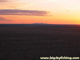
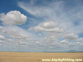
The Montana Hi-Line is one of the more fascinating places in Montana. To me at least, the Montana Hi-Line region symbolizes what Montana is all about – rolling prairie, endless fields of wheat, large herds of cattle, towering mountains in the distance and remoteness – all tucked under the beautiful “Big Sky” that Montana is singularly famous for.
For those who aren’t familiar with the term, the “Montana Hi-Line” refers to the northern part of Montana that is adjacent to US Highway 2 – or more or less about the first 100 miles of Montana that lies south of the Canadian border. The full Hi-Line in Montana stretches from the North Dakota to the Idaho border, for a distance of more than 650 miles. A trip down the Hi-Line is, due to this distance, a long one. (See the Hi-Line Maps page for maps of the region).
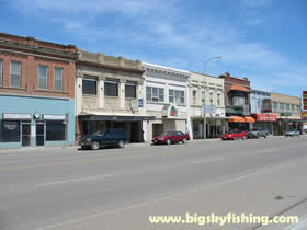
However, like most Montana residents, when we talk about the Hi-Line we generally mean that part of Montana on US Highway 2 that is between the North Dakota border on the east side and the Rocky Mountain Front on the west side. It is between these two points that a visitor to Montana truly sees what the Hi-Line is all about.
I first visited the Montana Hi-Line region in 1996 when moving to Idaho from the Midwest, deciding to take the long way in order to explore this area of Montana I had never visited before. Upon my permanent return to Montana in 1999, I’ve visited the Hi-Line several times – mainly passing through it on the way to someplace to generally either go hunting or to gather information and pictures for this website.
However, despite my many trips along the Hi-Line, I had never taken the time to fully explore this region. That all changed in June of 2004 when I woke up one day, realized I had about two weeks with nothing in particular planned, and had a peculiar urge to get out into the open prairie, away from the mountains for a bit (I lived in Kalispell at the time). So the next day I hopped in my truck and started a two-week voyage down the Montana Hi-Line to the North Dakota border, and then back again – with no particular plan or schedule.
The weather during this trip was typical June weather in Montana, a combination of sun, rain, clouds, heat and cold. Lodging consisted of a mix of sleeping in the bed of my truck, camping in my tent and lounging in a comfortable hotel in Glasgow while waiting out the rain.
The following pages in this section will cover this trip in detail, and provide information about the Hi-Line, including its history, its towns and the areas potential future. Be sure to visit the Hi-Line Photo Gallery section to browse the several hundred photographs that highlight this unique area of Montana, too.
I’ll state up front that this is not a true “travel guide”. If you are looking for where to grab the best cheeseburger, to locate the best hotel or where to find the latest and greatest shopping opportunities, you won’t find this information here. Instead, these pages will be a mix of my own observations and thoughts about the Hi-Line area, coupled with historical and factual information – all of which is illustrated by photographs. As such, it is my hope that anyone who has the time and patience to read this entire section (and it is long), should walk away with a good idea of what the Montana Hi-Line is like today.
As for the organization of this section, frequent visitors to Big Sky Fishing.Com will notice some differences. For those with too much time to kill, it would be a good idea to read these pages in the order listed in the left menu. This section covers the Hi-Line going from West to East – starting out near Cut Bank and ending on the North Dakota border, with a few interesting side trips thrown in, too.
I don’t claim to be a professional Montana historian. So if you find some factual errors, by all means, let me know. As much of this section of the site is a reflection of my own views and observations, too, it is also quite likely that someone out there may not necessarily agree with some of what is presented in this section. If that happens to be you, feel free to drop me a line too – just be nice about it. Lastly, if you like this section, by all means, let me know, too. (contact information).
Well, with that out of the way, let’s get started exploring the Montana Hi-Line.
Next Page : The History of the Montana-Hi Line
Copyright 2002 - 2018 Big Sky Fishing.Com
|
|
|