The Western Edge of the Montana Hi-Line
The Montana Hi-Line, at least according to most Montanan’s, runs between the North Dakota border on the east side to the town of Browning on the west side. True, US Highway 2 continues towards the Idaho border. However, in Montana, when people refer to the “Hi-Line”, they generally mean the part of Montana characterized by sweeping views, seemingly endless plains, numerous small towns and economic struggles against population loss.
As such, I suspect it is fitting to begin the journey down the Hi-Line in the town of Browning. If there ever is a town with massive potential in Montana, Browning has to be it. You see, Browning sits in a stunningly beautiful location, right at the base of the Rocky Mountain Front and Glacier National Park. Indeed, the entrance to Glacier National Park is about 10 minutes up the road in the town of East Glacier. Browning is also the main city that is located in the Blackfeet Indian Reservation.
Yet this town struggles. Of all the towns on the Hi-Line, Browning has to be the most depressing of towns to pass through. I suppose there are many reasons for this, but regardless of the reasons (I don’t claim to know anything about the struggles faced by people who grow up and live in Indian Reservations), it is very clear that Browning has some immense problems. I’ve read estimates that up to 70% of the population of Browning are unemployed, despite its stunning location that almost certainly should lead to tourist development. Moreover, alcohol and alcoholism is a chronic problem on the reservation. Additionally, the downtown area of Browning is hardly inspiring.
In a nutshell, Browning is a town with vast potential but has to overcome some immense social problems before it will ever be able to reach it. What’s the solution? I really have no idea. And that is all I have to say about Browning.
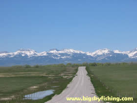
Browning, as mentioned, is located right at the base of the Rocky Mountain Front. As one travels east of Browning on US Highway 2, the traveler leaves the mountains slowly behind, entering the vast expanse of the Montana plains. Yet the plains are hardly flat. While there are indeed many flat areas in the plains of Montana, things are hardly “flat as a pancake” as many people expect.
Initially, as one travels east of Browning, the plains are almost exclusively grass since a combination of dryness and supremely high winds don’t make for real good agricultural conditions. As such, immediately beyond Browning the visitor will see large herds of cattle roaming around on the hilly plains.
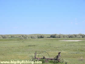
Soon, though, as one approaches the town of Cut Bank, the traveler will notice a subtle change. Agricultural conditions improve a bit as one travels east from the Continental Divide, with the soil becoming better, the wind a little less fierce and a touch more water. As such, as one approaches Cut Bank, vast expanses of grass start to be checker-boarded with agricultural fields here and there, particularly wheat.
Next Page : Cut Bank, MT
Copyright 2002 - 2018 Big Sky Fishing.Com
|
|
|