Some Final Thoughts About the Montana Hi-Line
This section about the Montana Hi-Line on Big Sky Fishing has been a big task to create. But it has been an enjoyable one, too. I always enjoy my travels down the Hi-Line, as I’m sort of a fan of big spaces and open views. And since hundreds of thousands of people pass through the Hi-Line every year on their way to Glacier National Park and other areas of western Montana, I felt some solid information about this part of Montana was needed on the site, even though at first blush it seems totally unrelated to the fishing theme of Big Sky Fishing.Com.
If you’ve read through all the articles and gone through all of the pictures, you should have a good idea of what the Hi-Line region of Montana is like. But in case you haven’t yet, or just need things summed up a bit (I have diarrhea of the word processor at times, spewing out endless amounts of printed word on my computer which some people may find rather daunting to fully read), this conclusion should hopefully brings things together a bit.
Quick Summary
The Montana Hi-Line region runs the full length of US Highway 2 in Montana, between the North Dakota border in the east to the Idaho border in the West. But in Montana, when most people talk about the Hi-Line region, we refer to the prairie part of the state, or the eastern 2/3 of Montana. Thus, when most people refer to the Hi-Line in Montana, they are talking about that part of Montana on US Highway 2 that is in-between the North Dakota border and Browning, Montana.
The primary business all along the Hi-Line region of Montana is agriculture. Particular, cattle grazing and wheat farming are the two main commodities. Other economic sources include some limited oil and gas development around Cut Bank and Shelby.
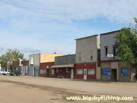
The Hi-Line region has been hit hard by the consolidation of the agricultural industry, which has led to fewer people working on larger and larger farms and ranches. This in turn has affected the local towns, leading to closures of many small town businesses. This is why you see so many abandoned farm and ranch buildings outside of town, and why many of the small towns on the Hi-Line have so many abandoned stores and homes inside them.
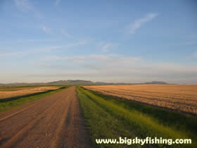
The Hi-Line region boasts a wide variety of geographical terrain. By and large, the area is primarily flat. By flat, though, I don’t mean “pancake flat.” Most areas on the Hi-Line have many rolling hills. Often times the hills aren’t even noticeable until you reach the top of them. In addition to these hills, larger mountains are found in the Sweet Grass Hills and in the Bears Paw Mountains.
The Hi-Line region, unlike many areas in Montana and elsewhere in the Great Plains, has a decent if not spectacular water supply. The Milk River flows through the vast majority of the area, and the Missouri River picks up where the Milk River ends at Fort Peck. Several large reservoirs, including Fresno Reservoir, Fort Peck Lake, Nelson Reservoir and Tiber Reservoir help provide water to the region as well.
The future of the Hi-Line region is mixed. Many towns on the Hi-Line seem well positioned to capitalize on future growth and society trends in the United States, while other towns are likely to continue to struggle. By and large, it seems like the county seats of each county are destined to do reasonably well in the future, while many of the smaller towns will continue to battle a loss of population and businesses.
Some Final Thoughts
Overall, the Montana Hi-Line is a region that many travel though but few people ever truly see. In general, people from out-state who travel the Hi-Line seem lacking in time or inclination to actually venture off of US Highway 2, so intent are they on just getting “out of” this part of Montana. As such, although hundreds of thousands of people visit the Hi-Line region each year, few of them spend any more time than is needed in this part of Montana. And rarely do visitors venture off of US Highway 2 to either explore the back roads of the region, or even to investigate the many small towns found along the highway.
And this is, in my view, kind of a tragedy. The Montana Hi-Line is a region that is just ripe for exploration. By taking some time and exploring the Montana Hi-Line region, a visitor will see many new and beautiful sights, can brag about how they visited a part of Montana that few in-state people ever even see, and will likely come away with a deeper appreciation of the prairie in general. Moreover, people who take the time to explore the side roads off US Highway 2 will wander through some great small towns that have changed little in the past few decades.
So…if you plan on venturing down the Hi-Line on a trip to Glacier National Park or some other popular tourist spot in Montana, make time in your schedule to explore the Hi-Line, even if it is for an just an extra day or two. You won’t be sorry you did.
Next Page : Photographs of the Montana-Hi Line
Copyright 2002 - 2018 Big Sky Fishing.Com
|
|
|