Helena, MT : Location & Information
Helena is more or less in the middle of the state, although it’s not the geographic center of Montana. Helena is about 80 miles to the southwest of Great Falls and is about 80 miles to the northeast of Butte. Interstate 15 also passes through town. Helena also has a small, commercial airport, too.
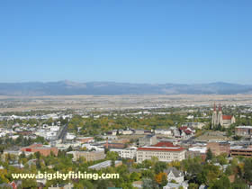
Helena’s location is quite scenic. The broad valley that expands to the east of town contrasts sharply with the mountains that rise to the west of town – especially since there are no foothills. The Belt Mountains also provide a scenic backdrop to Helena and lie about 30 miles to the east of town. The mountains outside of town are heavily forested, while the valley itself is a wide-open expanse of agricultural fields as well as some suburban sprawl.
See Google Map of Helena
Helena Weather
The weather in Helena, as it lies to the east of the Continental Divide, is actually fairly nice by Montana standards. The Continental Divide sucks most of the precipitation out, keeping Helena in a dry climate. Helena also receives much more sunshine than other Montana cities that are located to the west (like Butte, Missoula and Kalispell, where clouds are the norm). Winters can be very cold at times, but extremely cold weather tends not to hand around Helena for extended periods. And warm temperatures, even during the depths of winter, can occur.
Outdoor Recreation
If you like snow to play in but don’t like snow where you live, Helena is a good place to be. The mountains to the west of town tend to limit the amount of precipitation that falls in downtown Helena, while at the same time depositing a sizable snow pack that makes for good skiing at the local downhill ski area called Great Divide Ski Area, which is about 20 miles from downtown, near the tiny town of Marysville. Many snowmobile trails are also located up in the mountains outside of town.
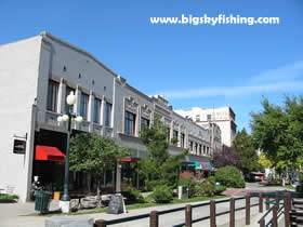
Helena, besides being the state capitol and playing host to a nicely restored and historic downtown district, is located in a very scenic area. Just to the west of town is the Continental Divide and the Helena National Forest. The National Forest has excellent hiking and hunting opportunities – not to mention some serious off road, mountain bike and 4x4 trails for the adventurous. The Helena National Forest is quite literally located a stone throw away from downtown, while the Lewis and Clark National Forest is scattered around in various spots to the north of the city.
The fishing around Helena is equally fine. Just down the road from Helena is Holter Dam. And the river that comes out of Holter Dam is the Missouri River, which has some of the finest rainbow trout fishing in Montana (see our Missouri River Fishing section for more information). And, if lake fishing or simple pleasure boating is more your style, the large and windy Canyon Ferry Lake lies just 20 miles from downtown. Several smaller lakes are also located nearby.
Several scenic drives are also located near Helena, including the Missouri River Recreation Road Scenic Byway, the Southern Rocky Mountain Front Backcountry Drive and the Smith River Region Backcountry Drive.
Where to Stay in Helena
Being the state capital, Helena has lots of business traffic which fills up hotels quickly - even during the off-season. As such, if you know you'll be staying in Helena, book a room in advance lest you end up staying at the Motel 6 - which I found to be "not so nice."
View all Hotels in Helena at Hotels.Com
Related Articles
Web Resources
|
Copyright 2002 - 2018 Big Sky Fishing.Com
|
|
|