|
|
| River Fishing | Lakes | Mountains | National Parks | Explore Montana | Outdoor Gear | Books |
| Explore Montana > Montana Scenic Drives > Judith River Backcountry Drive | Search Site |
|
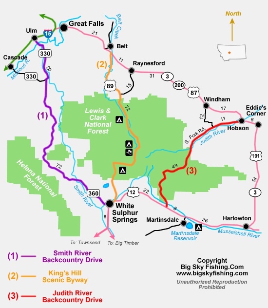
The Judith River Backcountry Drive
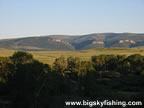
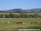
The Judith River Backcountry Drive is a remote, sixty-mile excursion through the Little Belt Mountains of Central Montana. The drive follows a series of primarily gravel roads between US Highway 12, near Martinsdale, and Hobson on US Highway 200. Highlights of the trip include great views of the Little Belt Mountains and nearby mountain ranges, the South Fork and main stem of the Judith River, a narrow and rocky canyon, and many beautiful meadows and valleys on the northern side of the Little Belt Mountains. Beginning on US Highway 12, eight miles to the west of Martinsdale, the Judith River Backcountry Drive heads north on a not-so-well-marked road called Spring Creek Road. Initially the road is paved, but switches over to a good-condition gravel road after two miles. For the next fourteen miles, the drive climbs steadily along the southern side of the Little Belt Mountains. The lower and the mid-elevations of this section of the drive are the most scenic, as the route passes through a nice mix of open meadows and forest. The views of the Little Belt Mountains and the Castle Mountains are excellent. Additionally, the snow-capped peaks of the Crazy Mountains are also clearly visible. As the route nears the pass, the views found at the lower elevations give way to thick forests. Fourteen miles from US Highway 12 (and three miles above Whitetail Camp Ground) is an unmarked “Y” road junction. The Judith River Backcountry Drive goes to the left. The road to the right, which actually looks in better condition, leads into the higher elevations of the Little Belt Mountains.
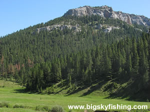
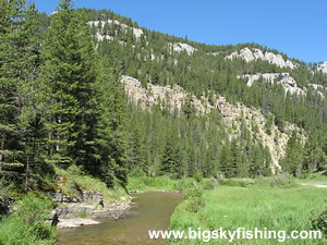
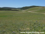
After the road junction, the scenic drive starts losing elevation, passing through thick forest, some of which is dying due to pine beetle infestation, with limited views. Six miles later the drive reaches another junction that is easier to discern. Visitors will want to turn right at this junction, following the sign that points toward Utica. Happily, the thick forests end less than two miles later as the Judith River Backcountry Drive emerges into a series of large, rolling meadows called Russian Flat. As the route meanders through these meadows, hints of something interesting ahead also starts to become visible. Once the scenic drive passes through Russian Flat, the route enters a very scenic, narrow canyon. The South Fork Judith River closely follows the road through this canyon, with rock cliffs and forested mountains rising steeply above the road and river. Additionally, those who enjoy camping need look no further, as the canyon stretch of the drive is simply loaded with ideal primitive camping locations. After meandering through the canyon for about eight miles, the road passes Indian Hill Campground and then soon emerges into the vast plain located to the north of the Little Belt Mountains. Initially, the road passes through a scenic valley filled with grasslands while following the Judith River. But after a few miles, as the route heads north toward its end in Hobson and the junction with US Highway 200, the grasslands give way to a more arid environment. Overall, the Judith River Backcountry Drive is a remote drive through a unique section of Montana. Although the eastern Little Belt Mountains won’t dazzle anyone with their vertical height, the scenic views of surrounding mountains ranges, the open meadows in Russian Flat, and the scenic canyon along the South Fork Judith River combine to make a trip down the Judith River Backcountry Drive a memorable and enjoyable experience. Quick Facts
|
| Montana Web Cams | Contact | Privacy Statement | About | Photo Use Policy | Advertising Info |