The Highline Trail
.gif)
As the vast majority
of hikers who day hike the Highline Trail begin their hike at Logan
Pass and end up at the Granite Park Chalet, this section on the site
will cover the features a hiker will see when starting a hike at Logan
Pass. The photographs in the Highline
Trail Photo Gallery also showcase the trail in this manner, too.
The Highline Trail,
as mentioned, begins at Logan Pass. This is very nice, as Logan Pass
has an elevation of around 6600 feet. As such, the Highline Trail is
unique among most hiking trails in Glacier National Park – it
actually loses a bit of elevation beyond the trailhead, instead of
heading incessantly uphill. The trail loses elevation gradually for
the first quarter mile or so as it makes its way through a very nice,
open, alpine meadow environment that is partially forested by some
evergreens that somehow manage to grow up in this very harsh climate
(Logan Pass is cold, windy and gets a ton of snow).
The trail soon hits
a very rocky point, as it makes its way around a cliff that is nearly
right above the Going to the Sun Road. As it would be a very nasty
fall from this part of the trail, Glacier National Park has taken some
of the risk away by installing a peculiar guard rail of sorts. Strung
along this part of the Highline Trail is a steel cable that is bolted
to the cliff via massive eye-joints. The steel cable itself is encased
inside a garden hose, of all things! Yet, while a bit “different”,
the hand rail works as advertised. For hikers a bit uneasy crossing
this section, just use your right hand and grab onto the handrail.
It should be noted that if conditions are good there isn’t a
huge need for the handrail, as the trail is generally at least 3 feet
wide in this part.
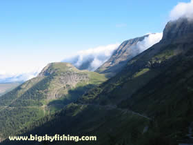
After passing around
this cliff, the Highline Trail makes a very gradual descent, staying
above the Going to the Sun Road (which continues to get further and
further below the hiker). The scenery is fabulous, with the mountains
of the Continental Divide (known as the “Garden Wall” in
this part of the park) towering above the hiker on the right side of
the trail. Meanwhile, to the left of the hiker, Mt. Oberlin, Mt. Cannon
and Heaven’s Peak dominate the skyline – making for some
outstanding views. And, directly in front of the hiker, is Haystack
Butte, a flat-top, smallish mountain that marks the “halfway”point
on the Highline Trail between Logan Pass and Granite Park Chalet.
After about a mile
of this gradual descent, and after crossing a number of seasonal streams
(fed by snowmelt), the Highline Trail begins a gradual ascent up, towards
a saddle that exists between the Continental Divide and Haystack Butte
(this saddle is un-named to the best of my knowledge, so I call it “Haystack
Pass” for reference).
After an additional
mile of gradual climbing, the hiker will emerge into a large, open,
alpine meadow environment that exists around Haystack Butte. Towering
above the hiker to the right is the Continental Divide and the “backside” of
Mt. Gould (you can’t see the true summit of Mt. Gould from the
trail, only its lower “backside”). From this open area,
the Highline Trail begins its first and only real major climb on the
whole trail, which consists of about a half-mile climb up to the top
of Haystack Pass (which is the saddle between Haystack Butte and the
Continental Divide). The trail in this section has one switchback.
It needs to be noted that the vertical gained in this climb isn’t
huge, just about 400 vertical feet, and the climb also isn’t
that steep. Compared to other hiking trails in Glacier National Park,
climbing up this little section is like a “walk in the park!”
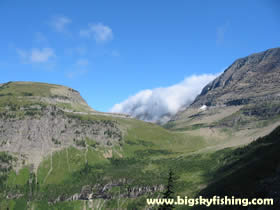
Haystack Pass lies
about halfway in-between Logan Pass and Granite Park Chalet. The pass
is also incredibly scenic, offering sweeping views in all directions.
And, to top it off, the pass is very open, pretty flat and has a ton
of large, flat rocks. As such, Haystack Pass has become the undesignated “lunch
stop” for hikers on the Highline Trail. As a word of warning,
guard your lunch. Ground squirrels are everywhere up at the pass, and
will happily and stealthily steal your food if you are not careful!
From Haystack Pass,
the Highline Trail makes one more short climb, most of it very gentle,
for about a half mile, as it nears the trails maximum elevation on
the hike, of 7,440 feet. The views of the Livingston Range are incredible,
with Heaven’s Peak dominating the skyline. Mt. Cannon, Mt. Oberlin
and Swiftcurrent Mountain also provide for some spectacular views.
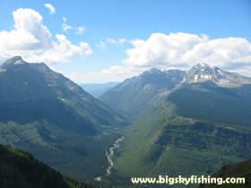
Additionally, about a mile down the trail from Haystack Pass the hiker
is rewarded with some nice views of the entire Lower McDonald Creek
Valley, including views of Lake McDonald.
 
Next
Page : Hiking
the Highline Trail, Continued
 Also
View the Highline Trail Photo Gallery Also
View the Highline Trail Photo Gallery
Hiking Gear & Equipment Guide for Glacier National
Park |
 |
Rain
Jackets : Get
the right type of rain gear for Glacier Park |
Top of Page
|