The Skalkaho Highway Scenic Byway
The Skalkaho Highway, also known simply as Skalkaho Pass, is a forty-five mile drive that runs between the Bitterroot Valley and the Philipsburg Valley. This paved and gravel route climbs through the Sapphire Mountains, a remote and seldom visited part of Montana. The drive follows Montana Highway 38 for its entire length.
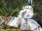
Highlights of the drive include the Sapphire Mountains, Skalkaho Pass, great views of the Philipsburg Valley, excellent camping along the West Fork Rock Creek and Skalkaho Falls.
Despite the State of Montana’s best efforts to promote this drive as a “must-do” activity for visitors, the views from this drive, while nice, aren’t superb by any means. There are far nicer, and remote, drives in Montana. That said, this drive is still enjoyable and makes for a nice, scenic shortcut between Hamilton and Philipsburg. In short, this drive isn’t worth going out of your way for, but if you happen to be in the area, it should indeed be a “must-do” activity.
The western portion of this drive begins three miles south of Hamilton, on US Highway 93. Since this drive has no services along it, Hamilton is the logical place to top off the tank and grab any supplied needed. As the route heads east, the drive slowly but steadily gains elevation as it passes through open agricultural lands.
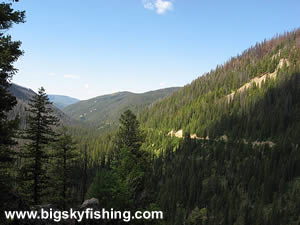
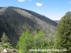
After about 10 miles, the road reaches the base of the Sapphire Mountains and the border of the Bitterroot National Forest. From here, the road begins and long, curvy climb toward Skalkaho Pass, which has an elevation of 7,250 feet. As the route passes through heavily forested terrain, the views are initially limited. However, once the drive reaches Skalkaho Falls (about two miles below Skalkaho Pass), the views do open in spots that allow for some decent views of the surrounding countryside, although a large fire scar is quite visible to the south of the route.
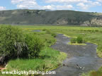
From the top of Skalkaho Pass, which offers no views as the pass is flat and heavily wooded, the byway starts losing elevation and soon starts following the West Fork Rock Creek. Those looking for excellent primitive camping spots need look no further, as numerous spots exist right along the river.
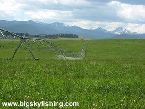
Once the Skalkaho Pass Scenic Byway leaves the National Forest, the road soon becomes paved and the views open up. This is my own personal favorite part of the drive. From the eastern section of the Byway, fields of hay and lush grass fill the Philipsburg Valley while tall, snow-capped peaks surround the valley itself.
The route ends in the Philipsburg Valley, at the junction with Rock Creek Road, which is part of the scenic Philipsburg Valley Loop. However, technically speaking, the Skalkaho Road continues toward Philipsburg and Montana State Highway 1. The portion of the drive between the junction with Rock Creek Road and Highway 1 offers superb views, so if you happen to take the Skalkaho Pass Road, be sure to continue down to Highway 1. The views won’t disappoint.
Overall, the Skalkaho Highway is a scenic route through the Sapphire Mountains. The drive isn’t spectacular by any means, but it’s still worth doing. And the eastern part of the drive does, in many ways, define what Montana is all about – vast valleys surrounded by towering mountains.
Quick Facts
- Length: 45 miles.
- Highlights : Sapphire Mountains, Skalkaho Falls, Philipsburg Valley, West Fork Rock Creek
- Road Type : Gravel and Paved.
- Nearby Towns : Hamilton, Philipsburg
- 4wd needed? : No.
- Traffic : Light
- Trailers? : Yes, but portions of the drive are narrow with limited turnouts. So beware.
- Season : Closed during the winter. Highway usually fully opens sometime in May or early June. Lower elevations of the road (outside of the National Forest) are open year-round. During the winter, the closed portion of the road is used for snowmobiling.
Map of the Skalkaho Highway Scenic Byway
The map below shows the route and location of the Skalkaho Highway in Montana, along with several other nearby scenic drives.

|
Where to Stay & Other Services
There are no services of any kind along the Skalkaho Highway. However, Hamilton (which is three miles north of the western starting point of the Byway), has extensive services, shopping, food and lodging options. Philipsburg, on the eastern end of the Byway, has all the basics.
Camping spots are plentiful along the Skalkaho Highway. About half of the drive passes through National Forest, allowing for primitive camping almost anywhere. In particular, there are many fine primitive camping spots on the eastern side of Skalkaho Pass along the West Fork Rock Creek.
For those seeking to stay out of the rain and away from the bears, the nearest lodging options are in the town of Hamilton. The Super 8 in Hamilton is great and is also pet friendly (I've stayed three times with my cat).
Missoula, however, offers the great lodging options but is about 60+ miles away.
In Philipsburg, there are several small hotels and motel but they aren't available for online booking through Expedia/Hotels.Com/etc.
|
Related Articles & Information
|
|