The Centennial Valley Backcountry Drive
The Centennial Valley Backcountry Drive follows the same road for its entire distance between Monida and Henry’s Lake, making it nearly impossible to get lost once you are actually on the road. However, the road the drive follows goes by many names, including Montana Highway 509, Red Rock Pass Road and South Valley Road. The good news is that you don’t need to know any of these road names since the road itself has no road name signs or markings!
Instead, when beginning the drive in Monida, just get off the Interstate and follow the only road that heads east, a road that helpfully does have a sign pointing towards the Red Rock Lake Wildlife Refuge.
The road the Centennial Valley Backcountry Drive follows is wide, all-season but, keeping with it’s forgotten about location, can be in nasty in spots since it seems the Montana Department of Transportation has forgotten this road even exists. Now, by nasty I don’t mean four-wheel drive type nasty. Instead, perhaps a better word might be “unpleasant,” as there are some long sections of the drive, particularly to the west of the Red Rock Lake National Wildlife Refuge, where the road is downright ugly to drive. In these sections the road, although wide, is full of small holes and washboards. If that wasn’t enough, part of the road seems almost built on the top of a mosaic of rocks, making travel down stretches of this drive a rather “jarring experience” akin to driving down the middle of a railroad track.
Of course, someday the Montana Department of Transportation might again re-discover this road and grade it, turning what was a bumpy ride in 2010 into the Interstate highway smooth route that it once was. Until then, though, visitors need to beware that parts of the road will test patience and sanity – not to mention their vehicles shocks and struts.
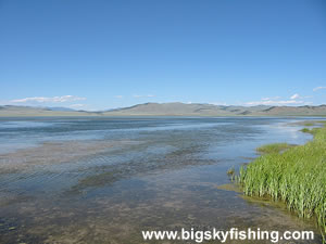
Although there are no services along the route, there is a nice but rather buggy campground located in Red Rock Wildlife Refuge, along the shores of Upper Red Rock Lake. In the rare event the campground is full or if the bugs are too bad, primitive camping is allowed in most areas of the refuge, too. Just stay away from the water and marshy areas to avoid the worse of the bugs.
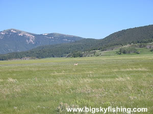
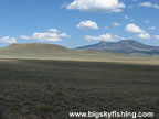
For most of its length, the Centennial Valley Backcountry Drive parallels the northern base of the Centennial Mountains, providing views that just get better and better the further a visitor travels east from Monida. Although this area has seen some fire activity recently, the fire scars in no way detract from the beautiful scenic vistas.
Red Rock Pass, the lone pass the route crosses, is a moderately-high elevation pass (7120 feet), but it’s a fairly easy climb to reach it. Even vehicles with trailers should have no issues crossing Red Rock Pass, except during periods of very wet weather or, rather obviously, when the road is snow-covered.
Those who find the drive through the Centennial Valley doesn’t provide enough adventure should fear not. Numerous side-roads skirt along the northern shore of Upper and Lower Red Rock Lake. Additional side-roads then lead up into the Gravelly Range and Ruby Mountains, where they meet up with the Gravelly Range Road Backcountry Drive and the Ruby River Road Backcountry Drive. Just be warned that, when wet, these side roads are slick, muddy and sticky – all at the same time.
Overall, the Centennial Valley Backcountry Drive is a route I love but I suspect others may not. To enjoy this drive, a visitors needs to enjoy massive, sweeping views in a very empty place. Those in search of trees definitely will not enjoy this drive, since the only place the road passes through forest is across Red Rock Pass and into Idaho. Instead, the Centennial Valley Backcountry Drive is a route that caters to those who enjoy visiting places few others ever do, and who appreciate the beauty found in an empty and forgotten land; a place that is fully fitting to be used for a Yellow Pages television advertisement.
Quick Facts
- Length: 53 miles
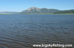
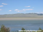
- Highlights : Red Rock River, Red Rock Lakes, Centennial Mountains, Red Rock Lake National Wildlife Refuge
- Road Type : Gravel
- Nearby Towns : Lakeview, Monida
- 4wd needed? : No, except during mud season or periods of extended wet weather
- Traffic : Very Light
- Trailers? : Yes
- Season : Year-round, weather permitting
Return to First Page of Article 1 | 2
Where to Stay & Other Services
There are no services of any kind along the Centennial Valley Backcountry Drive, nor are there any services near the beginning/end points of the drive. Thus, be sure to get whatever you need before traveling down the route.
The best places for gas and other supplies include Dillon, West Yellowstone, Ennis and, for the basics only, Lima.
For lodging, there's a few cities to choose from. Book early - very early - if you want to stay in West Yellowstone or Ennis.
A developed campground is locted along the southern shore of Upper Red Rock Lake (see map of Red Rock Lake National Wildlife Refuge). Primitive camping is also allowed in most areas of the refuge, as well as the surrounding BLM and National Forest lands.
For lodging with electricity, coffee and the Internet, the best places to find hotels is in Dillon and West Yellowstone. |
Related Articles & Information
|
|