The Ruby River Road Backcountry Drive
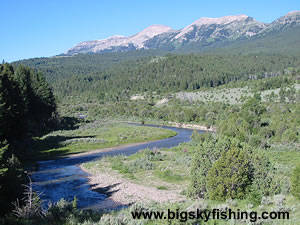
The sixty-four mile Ruby River Road Backcountry Drive runs between the empty Centennial Valley and the town of Alder, Montana. For much of its distance, the route passes in-between the Snowcrest Mountains that lie to the west and the Gravelly Range that rises to the east, providing superb views of towering snow-capped mountains.
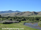
Highlights of the drive include Ruby Reservoir, the Ruby River, and excellent views of the Snowcrest and Gravelly mountains.
Unlike the Gravelly Range Road Backcountry Drive, which runs along a high-altitude plateau, the Ruby River Road Backcountry Drive for the most part stays at lower elevations, down in the valley. For this reason, the Ruby River Road Backcountry Drive opens up much earlier in the season for travel.
The Ruby River Road Backcountry Drive follows one road, although the name of that road changes several times from beginning to end. The surface of the road ranges from good-conditioned blacktop, to all-season gravel, to a short section of dirt in the Centennial Valley.
During normal weather conditions, normal passenger cars should have no problems driving the entire route, although some ruts will have to carefully avoided in spots. However, during wet weather or following periods of heavy rain, two-wheel drive vehicles are likely to struggle on the southern section of the drive.
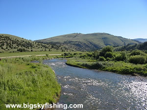
Beginning in Alder, Montana, the Ruby River Road Backcountry Drive heads south on a paved road called Ruby River Road. The road parallels the scenic Ruby River for much of this distance, and several fishing access sites exist.
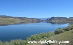
After twelve miles, the road reaches Ruby River Reservoir, which has excellent fishing. A few miles south of Ruby Reservoir, the road turns into an all-season gravel road. The road meanders through the Ruby Valley, paralleling the Ruby River. Although the road follows the Ruby River, access to the river is extremely limited due to private landholdings, many of which are “pay to fish.”
About fifteen miles from Ruby Reservoir, the route passes through a “notch” in the mountains and enters the National Forest. The road soon turns south and begins to follow the eastern base of the Snowcrest Range. The views on this stretch of the road are superb, as the high peaks of the Snowcrest Range march to the south for over twenty-miles.
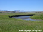
The Ruby River Road Backcountry Drive passes by a nice campground, called the Cottonwood Campground, about thirty-six miles from Alder. This campground is the only developed campground along the drive. The Cottonwood Campground is located right along the Ruby River and is a great place to spend the night.
As the drive heads south from the campground, it follows the Ruby River while slowly gaining elevation. About ten miles from the campground, the drive reaches the junction with the Gravelly Range Road Backcountry Byway (on a map this road is sometimes called the Eureka Basin Road).
Soon after the road junction, the Ruby River Road Backcountry Byway leaves the Ruby River behind and begins a short climb across a low pass, before dropping down into the expansive and treeless Centennial Valley. The route ends about fifteen miles later, at the junction with Highway 509, which is part of the Centennial Valley Backcountry Drive.
Overall, the Ruby River Road Backcountry Drive is a scenic journey through the seldom-visited Snowcrest Rang of Montana. What’s nice about this route is that it can be seamlessly combined with the Gravelly Range Road Backcountry Drive and Highway 287 (which runs between Ennis and Alder) to create a long, scenic loop.
Quick Facts
- Length: 64 miles
- Highlights : Ruby River, Ruby Reservoir, Snowcrest Range, Ruby Range, Centennial Valley
- Road Type : Primarily gravel. Paved between Alder and Ruby Reservoir.
- Nearby Towns : Alder, Monida, Sheridan
- 4wd needed? : No, if roads are dry
- Traffic : Very light
- Trailers? : Yes
- Season : Not maintained for winter travel in the mountains
Where to Stay & Other Services
There are no services along the scenic drive. Visitors beginning the drive from the south should get their supplies in Lima or Dillon. Those beginning the drive from the north can pick up supplies in Ennis, Alder and Sheridan.
There is no lodging along the route, although there is some guest ranches along the Ruby River that cater to the angler who wants to fish in private waters for trophy trout.
For camping, the Cottonwood Campground is the only campground along the route, although primitive camping is allowed where the route passes through the Beaverhead-Deerlodge National Forest. |
Related Articles & Information
|
|