Sawtell Peak Scenic Drive
The Sawtell Peak Scenic Drive is a short, twelve-mile route that climbs to the top of the 9875-foot summit of Sawtell Peak. The route follows a well-conditioned gravel road, called Sawtell Peak Road, between the town of Island Park, Idaho, and Sawtell Summit.
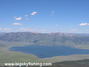
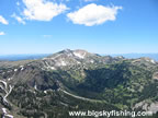
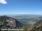
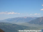
From the summit, the views of the surrounding area are magnificent. From the top, the visitor gets superb views of Yellowstone National Park, the Centennial Valley in Montana, Henrys Lake in Idaho and the Madison Valley in Montana. The Grand Tetons in Wyoming and the Pioneer Mountains in Montana are also visible way off in the distance.
The Sawtell Peak Road, while in good condition, does climb quite steeply and has many sharp turns and switchbacks. Due to the steep nature of the climb, cars with trailers, while not prohibited, aren’t advised. A normal passenger, however, will have no problems driving the route except during periods of extremely wet weather.
From Island Park, the route heads to the northwest, passing by some summer homes on the flat section of the drive. After a few miles, the road enters the national forest and begins a steep climb toward the summit of Sawtell Peak, gaining more than 3000 feet of elevation.
The reason there is such a well-conditioned road up to the top of a lonely mountain is because the FAA operates a flight traffic control radar station from the summit. The area right around the radar station is fenced and not open to visitors.
The Sawtell Peak Road is closed between November 1st and June 1st. Although the road is maintained during the winter to allow access to the FAA station, the road is gated during the winter months to prevent unauthorized access to the top of the mountain. Additionally, snowmobiles are also prohibited from using the road during the winter.
Overall, thousands of people a day pass through Island Park on Highway 20, usually on their way to Yellowstone National Park and the entrance point at West Yellowstone. Yet few even know of the existence of this short, relatively easy scenic drive that lies right off the highway in Island Park, Idaho. Anyone who will be in this part of Idaho or will be visiting West Yellowstone should find the time to take this scenic drive, as the views from Sawtell Peak are excellent.
Quick Facts
- Length: 12 miles
- Highlights : Superb views of all nearby mountain ranges and scenic valleys from the peak of Sawtell Peak Summit.
- Road Type : Gravel
- Nearby Towns : Island Park, West Yellowstone
- 4wd needed? : No
- Traffic : Light
- Trailers? : Yes
- Season : Closed November 1st to June 1st.
Where to Stay & Other Services
There are no services along the scenic drive. However, at the beginning of the drive, in Island Park, there are plenty of places to pick up gas and other supplies. West Yellowstone is also nearby, and offers pleny of lodging options.
There are no designated campgrounds along the route, although a few spots can be used for primitive camping. The best camping spots, though, are found on lower elevations, in the various developed campgrounds along the Snake River and around nearby Henrys Lake.
|
Related Articles & Information
|
|