The Sun River begins in the mountains at the confluence of the North and South Fork of the Sun River, on the eastern edge of the Bob Marshall Wilderness Complex.
From its origin, the river flows for five miles and pass through two dams, the Gibson Dam and the Sun River Dam located three miles further downstream. The three mile stretch between the dams consists of almost solid whitewater and is very difficult to fish from a boat.
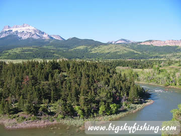 |
| Sun River Along Rocky Mountain Front |
Below the Sun River Dam and lasting for the next twenty-five miles, the Sun River turns into an isolated and wild river. The river first passes through the Sun River Canyon, a steeply sloped canyon providing wild and remote scenery on the edge of the Rocky Mountain Front. This section of the river has extensive rapids, depending on river flows, making any float or fishing trip a memorable experience.
Downstream from Sun River Canyon, the whitewater ends as the river spills out onto the high prairie, traveling in a southeast direction. Vegetation is sparse as the sun passes through the prairie.
After eighty miles from Sun River Dam, the river nears the town of Vaughn. Below Vaughn, the river slows and often runs muddy. Motors are allowed on this stretch of the river. Due to slow current and high winds that are prevalent along the Rocky Mountain Front, paddling can be difficult in a raft or canoe.
The Sun River continues in a slow, meandering fashion below Vaughn, emptying into the Missouri River at Great Falls seventeen miles later.
Fishing the Sun River
The Sun River has the potential to have incredible fly fishing, but irrigation demand and frequent low water prevents successful trout reproduction. Still, despite the massive irrigation demands put on the Sun River, the Sun still offers an angler with good fishing possibilities in a remote and scenic section of Montana. While the Sun River is not a destination river for anglers, it does provide pleasant fishing away from the crowded rivers elsewhere in Montana, such as the Missouri River.
Above Gibson Reservoir
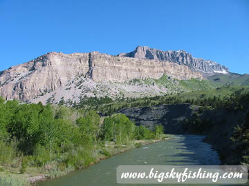 |
| Beautiful Scenery Along the Sun River |
The Sun River has excellent fly fishing above Gibson Reservoir, as well as in the two forks that create the river, the South Fork Sun River and the North Fork Sun River. Both these forks are located in the Bob Marshall Wilderness Complex. Anglers will need to hike to reach these seldom fished waters. An angler who is willing to hike will enjoy a river with low fishing pressure and provides outstanding scenery in a remote setting. While the fish are not huge in these forks, fly fishing is not difficult, as the rainbows, cutthroats and brook trout will zap most flies thrown their way.
The two forks converge five miles above Gibson Reservoir, creating the Sun River. Like its forks, this section of the river also provides fine fishing. Access to this section of the river also requires a hike, as the road ends at Gibson dam. Because access is difficult, fishing pressure is low and the fish will take most flies floated their way. Similar to the forks upstream, few of the fish are large. Since the water in the river at this point mainly comes from snow melt, the water is cold and low in nutrients.
Gibson Reservoir to Willow Creek Reservoir
Although the river is no longer in a wilderness complex, the Sun River is just as difficult to access in this stretch as further upstream. The river first flows through Sun River Canyon. In Sun River Canyon, fishing from a boat is difficult because of almost constant whitewater and fast currents. Unfortunately, access is also difficult by trail, requiring some hikes along the river on steep, slippery, rocky trails. Fishing pressure is very low, although some whitewater enthusiasts make the trip down the canyon in kayaks and high quality rafts.
Although Sun River Canyon has difficult access, it can provide some excellent fishing. Rainbow, cutthroat and brown trout are all found here in solid numbers. The trout in general are not large, averaging ten to twelve inches.
The Sun River in the canyon stretch has beautiful pools. Fly fishing dry flies work well on this stretch, but the larger fish are caught using streamers in the deep pools and along the banks. Attractor nymphs also work well. Use sinking or sink-tip lines with weighted flies to reach the deep holes.
Below the canyon, the Sun River mellows out but still has a decent current. Long riffles, occasional pools and nice runs all provide enticing fishing spots. Standard dry flies like the Parachute Adams and Elk Hair Caddis work well, especially in the morning and evening hours. Streamers can still be used in and around the pools. And, of course, hoppers should always be in the fly box during late summer, since the Sun River flows through excellent hopper country once it leaves the mountains.
Willow Creek Reservoir to Missouri River
Below Willow Creek Reservoir, the river has limited trout fishing, with most trout being brown trout. Fishing pressure is very low. Streamers and nymph patterns, as well as hoppers in late summer, are the best flies to use. Just keep in mind the numbers of trout on this section are fairly low, and get lower the further downstream an angler is from Willow Creek Reservoir. Spin fisherman will have plenty of opportunity to catch northern pike, both in Willow Creek Reservoir and in the river downstream, using large spoons.
Floating the Sun River
The Sun River becomes floatable beneath Gibson Dam, although most floats start three miles downstream below Sun River Dam. The three miles between Gibson Dam and Sun River Dam has extensive whitewater, and is not a place for beginner floaters. The river is also fast and bouncy, making fishing difficult from a boat.
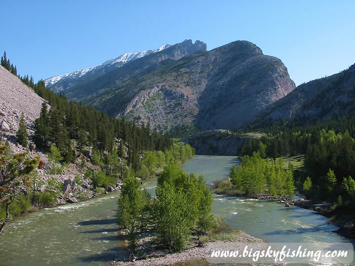 |
| Swift Flows of the Sun River |
Below Sun River Dam, the river passes through Sun River Canyon. The canyon stretch provides a steady diet of Class II and Class III rapids for nearly nine miles. The often narrow width of the river requires experienced paddlers to work their way around the many rocks that litter the river.
After the river emerges from the canyon, the Sun maintains a decent current but loses the whitewater as it flows through a mix of high prairie and rocky country along the Rocky Mountain Front. No rapids or dams are on the Sun between the canyon and Willow Creek Reservoir.
Willow Creek Reservoir is the best take out point for floaters coming down from Sun River Dam. Floating is not popular below Willow Creek Reservoir due to five diversion dams, all of which require a portage. Also, beginning seven miles downstream from Floweree Dam, several high drops exist, which also require a portage around except by experienced floaters in a whitewater kayak or raft.
The first diversion dam is sixteen miles below Floweree Dam and the last dam is forty miles below Floweree Dam, thirteen miles upstream from Vaughn.
Below the last diversion dam, the Sun runs unobstructed to its confluence with the Missouri River. The current is fairly fast until the bridge near Vaughn. Below the bridge, the river slows and is often muddy. Depending on wind conditions, this stretch of the Sun River can be tedious for individuals in canoes and rafts. Motorboats on this stretch of river are allowed and frequently used.
River Miles
Listed below are selected river miles for the Sun River, from its source to its confluence with the Missouri River near Great Falls, Montana.
- Confluence of North Fork and South Fork Sun River: 106
- Gibson Dam: 101
- Access above Sun River Dam: 98
- Sun River Dam and Access Site: 97
- Willow Creek Reservoir: 71
- Lory Road Bridge: 50
- Sims Fairfield Road Bridge: 45
- Fort Shaw Access Site: 37
- Highway 200 Road Bridge: 30
- Ulm-Vaughn Road Bridge: 17
- Manchester Road Bridge: 12
- Interstate 15 Bridge: 2
- Confluence with Missouri River : 0