The Boulder River Backcountry Drive
The Boulder River Backcountry Drive is a forty-seven mile drive that leads into the heart of the Absaroka Mountains south of Big Timber, Montana. The route closely follows the Boulder River, which provides excellent fishing and, in its upper reaches, superb access. The first twenty or so miles of the drive follow a paved road, before turning to a gravel surface for the remainder of the route. The drive, which is a one-way trip, dead-ends at a popular trailhead that lies at the edge of the Absaroka-Beartooth Wilderness Area.
Highlights of the drive include Natural Falls Bridge State Monument, the Boulder River, beautiful agricultural fields south of Big Timber and superb views of the Absaroka Mountains and the Absaroka-Beartooth Wilderness Area.
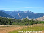
Beginning in Big Timber, the Boulder River Backcountry Drive heads south on Highway 298. The road meanders its way through open grasslands and irrigated hay fields, with the mass of the Absaroka Mountains providing a scenic backdrop.
After sixteen miles, the route reaches McLeod, a tiny town with a cute little schoolhouse. Just south of McLeod, the route reaches the junction with the West Boulder Road, which is part of the West Boulder Backcountry Drive.
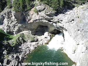
Beyond the junction with the West Boulder Road, the Boulder River Backcountry Drive continues heading south, toward the Absaroka Mountains. Close to the border with the National Forest, the road passes by Natural Bridge Falls State Monument. This monument is well worth stopping for, as Natural Falls is a unique site. During high water levels on the Boulder River, the river flows through two natural tunnels in the rock while also cascading over a 100-foot waterfall, called Boulder Falls. During low water levels, the river only flows through one or both of the natural tunnels.
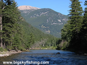
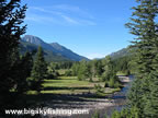
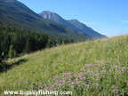
Soon after Natural Bridge, the road turns to gravel and then enters the National Forest, where the route begins to thread between the high peaks of the Absaroka Range that rise up on both sides of the road and the Boulder River. While the forest tends to limit the views somewhat, many meadows offer superb views of the mountains. Additionally, since the road closely follows the Boulder River, many spots along the river provide open and beautiful views.
For those with fly fishing gear, the Boulder River near the National Forest boundary offers superb fly fishing for trout. This part of the Boulder River receives little fishing pressure and access is superb, since the road closely follows the river.
Those with camping gear will also have no shortage of places to camp. Several developed campgrounds are located in the National Forest along the route. Additionally, many attractive primitive camping spots are located right along the river and provide a superb spot for longer-term camping in a quiet and scenic environment.
As the route continues heading south, the road starts to narrow and the views become more limited. The drive ends where the road ends, at a popular trailhead at the boundary of the Absaroka-Beartooth Wilderness Area.
Overall, the Boulder River Backcountry Drive is a scenic trip that follows the Boulder River deep into the Absaroka Mountains. Whether the visitor seeks superb trout fishing, excellent camping along a scenic river or just wants to visit a part of the Absaroka Mountains that few people ever see, the Boulder River Backcountry Drive is a scenic route well worth taking.
Quick Facts
- Length: 47 miles
- Highlights : Absaroka Mountains, Boulder River, Boulder Valley, Natural Bridge Falls State Monument
- Road Type : Paved (about 20 miles) and Gravel (about 27 miles)
- Nearby Towns : Big Timber, McLeod
- 4wd needed? : No
- Traffic : Light
- Trailers? : Yes
- Season : The portion of the drive lying between Big Timber and the National Forest is open year-round, weather conditions permitting. The National Forest portion of the drive is not maintained for winter travel.
Map of the Boulder River Backcountry Drive
The map below shows the route and location of the Boulder River Backcountry Drive in Montana, along with other nearby scenic routes.

|
Where to Stay & Other Services
There are no services or lodging along the route. However, Big Timber has plenty of places to pick up supplies of all types.
Camping is abundant along the route once the scenic drive enters the National Forest. Several developed campgrounds are located along the route, and there are numerous primitive camping areas set right next to the Boulder River.
For lodging, the best place to find a hotel room is in Big Timber. There are also several guest/fishing ranches along the route, too.
|
Related Articles & Information
|
|