|
|
| River Fishing | Lakes | Mountains | National Parks | Explore Montana | Outdoor Gear | Books |
| Explore Montana > Montana Scenic Drives > Beartooth Highway Scenic Drive, Page 1 | Search Site |
|
The Beartooth Highway Scenic Drive
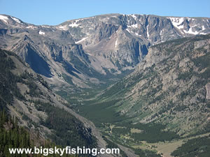
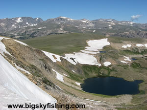
The fifty-mile long Beartooth Highway is one of the pre-eminent scenic drives in Montana and Wyoming. The highway, which runs between Red Lodge and the junction with Highway 296 in Wyoming, crosses a high-elevation plateau called the Beartooth Plateau. The views along the drive are spectacular, with the peaks of the Beartooth Mountains—which are the highest mountain range in Montana—dominating the view. Moreover, unlike most other high-elevation scenic drives in the continental United States, the Beartooth Highway spends considerable time above tree line, meandering for more than ten miles across the alpine tundra of the Beartooth Plateau. Unlike most other scenic drives profiled on this site, the Beartooth Highway is a federal scenic byway and has a designation as an “All-American Road,” of which there are only five. The full-length of the Beartooth Highway is actually sixty-nine miles, running between Red Lodge and the northeast entrance to Yellowstone National Park outside of Cooke City. Since the most stunning portion of the drive is the high elevation and lake region between Red Lodge and junction with the Chief Joseph Scenic Byway, this page focuses on the first fifty miles of the drive outside of Red Lodge, Montana.
The Beartooth Highway, opened in 1936, was a road that almost never happened. Designed as a “make work” project during the height of the Great Depression as part of a bill designed to increase access to US National Parks, the road spawned significant opposition in Washington, DC, due to the high construction costs, the lousy economy and the simple fact that the road essentially went nowhere. Unlike most other high-elevation mountain roads built to link various places together out west, the sole purpose of the Beartooth Highway was to be a scenic drive. Moreover, once someone ran the mileage of the proposed Beartooth Highway, it was discovered that the road was too long, by eight miles, to even qualify under the bill. This problem, however, was neatly solved by having the Forest Service “assume ownership” of the section of road to the south of Red Lodge to the point before the road started to climb out of Rock Creek Canyon. This shortened the road just enough to allow the Beartooth Highway to qualify under the bill for funding. Despite the opposition and legal issues, the road finally gained Congressional approval and construction started in 1931. Considering the technology of the time, and the very short season available to build anything, the fact that the Beartooth Highway was built in less than five years is rather remarkable. New engineering techniques were developed specifically for constructing the road, and building the six-mile steep climb between Rock Creek Canyon and the Beartooth Plateau (outside of Red Lodge) proved particularly challenging. Another oddity of the Beartooth Highway is that the road is essentially an “orphan road.” That is, the United States Governments—despite its best attempts—has failed to convince the State of Montana or the State of Wyoming to assume full ownership [and thus maintenance costs] of the road. That Montana and Wyoming have studiously avoided owning the road should hardly be surprising considering the considerable challenges and costs involved in maintaining a high-elevation mountain road. As a result, the National Park Service and the Forest Service, by default, own the road. Through an agreement with the federal government, the State of Montana maintains the Montana portion of the drive, with the federal government picking up the cost. Oddly, the State of Wyoming isn’t responsible for the maintenance of the road in Wyoming. That honor instead falls to the National Park Service. Today, the Beartooth Highway between Red Lodge and the junction with the Chief Joseph Scenic Byway is a seasonal highway. The road traditionally opens on the last Saturday in May, although weather at times can delay those plans. The road will then be open the rest of the summer and into mid-fall, before winter weather typically shuts the road down in late-October or early-November. Article, with maps and more photos, continued on next page 1 | 2
|
| Montana Web Cams | Contact | Privacy Statement | About | Photo Use Policy | Advertising Info |