The Beartooth Highway Scenic Drive
The northern/eastern starting point of the Beartooth Highway begins in Red Lodge, Montana, on Highway 212. Initially, the drive is flat for several miles before it enters the beautiful Rock Creek Valley. Within this valley, several side-roads lead deeper into the valley. The valley is also home to many developed campgrounds, some of which are named for the construction companies that built the road.
About seven miles south of Red Lodge, though, the flat and easy going ends as the Beartooth Highway begins a steep and twisty climb up the mountains. This six-mile long climb has a steady, 6% grade and has several sharp switchbacks. Despite this, the road is surprisingly wide, has many turn-off spots, and is in excellent condition.
One of the must-do stops on the Beartooth Highway occurs on this climb, at Rock Creek Vista Point. This scenic overlook, with an elevation of 9,190 feet, has a fairly large parking area and provides absolutely stunning views of Rock Creek Canyon far below.
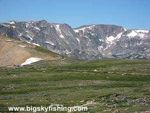
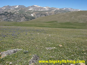
Beyond the scenic overlook, the Beartooth Highway continues its steady ascent up to the alpine section of the drive on the Beartooth Plateau. At about an elevation of 10,000 feet the road ascends above tree line and starts to cross through the alpine tundra found along the Beartooth Plateau. Although the major steep climbs are now over, the road still has plenty of smaller climbs with many twists and turns ahead.
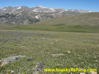
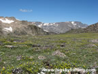
The views from the alpine section of the drive along the Beartooth Plateau, which is over ten miles long, are stunning. The high peaks of the Beartooth Mountains dot the landscape to the north, while numerous small ponds and lakes are visible far below the road.
After crossing the Beartooth Plateau for about eight miles, the Beartooth Highway reaches the highest point of the drive at West Summit, which has an elevation of 10,974 feet. From the summit, visitors have not only superb views of the highest peaks of the Beartooth Mountains, but also excellent views of the distant North Absaroka Mountains in Wyoming.
From the summit, the Beartooth Highway starts descending steadily, passing by a number of small ponds and lakes. Soon after the highway descends below tree line, the route passes by the very scenic Beartooth Lake, the largest lake along the drive.
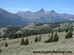
As the highway continues to lose elevation, the views of the Beartooth Mountains disappear somewhat since the forest grows thicker. However, this part of the drive provides superb views of many mountains in Wyoming, especially from several overlooks that exist near the junction with the Chief Joseph Scenic Byway.
The Beartooth Highway, for purposes of this site, ends at the junction with the Chief Joseph Scenic Byway fourteen miles to the east of Cooke City. However, as mentioned on the previous page, the full-designated highway runs all the way to Cooke City. From the junction with the Chief Joseph Highway to Cooke City, the Beartooth Highway primarily travels through valleys surrounded by tall mountain peaks. The road also follows the Clarks Fork Yellowstone River for part of the distance.
Overall, the Beartooth Highway is a stunning drive across a high-alpine plateau. The views from the drive are like few others in the United States, and the lengthy drive through alpine tundra allows for superb views of the Beartooth Mountains and other nearby mountain ranges. Anyone who is heading to Yellowstone National Park should definitely set aside time in their plans to take this beautiful drive—as anytime spent on the Beartooth Highway will always be time well spent!
Quick Facts
- Length: 50 miles
- Highlights : Beartooth Mountains, Beartooth Plateau, Alpine Tundra
- Highest Point : 10,927 feet (in Wyoming). Highest elevation in Montana is 10,320 feet.
- Road Type : Paved
- Nearby Towns : Red Lodge, Cooke City
- 4wd needed? : No
- Traffic : Moderate to Heavy
- Trailers? : Yes
- Season : Closed during the winter
Additional Reading
Return to Previous Page 1 | 2
Map of the Beartooth Highway Scenic Drive
The map below shows the route and location of the Beartooth Highway Scenic Drive in Montana, along with other nearby scenic routes.
|
Where to Stay & Other Services
There are no services or lodging along the route. However, both Red Lodge (northern starting point) and Cooke City (near the southern starting point) have ample services. Red Lodge, in particular, has everything anyone could ever need for outdoor excursions or a day on the Beartooth Highway.
|
Related Articles & Information
|
|


