
|
|
| River Fishing | Lakes | Mountains | National Parks | Explore Montana | Outdoor Gear | Books |
| Explore Montana > Montana Scenic Drives > Going to the Sun Road | Search Site |
|
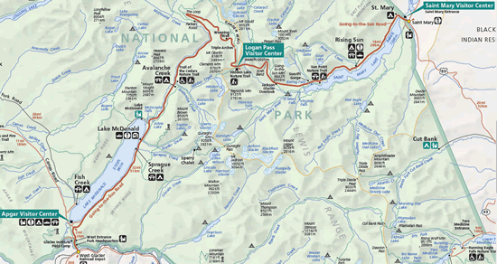
The Going to the Sun Road
The Going to the Sun Road is the crown jewel of scenic drives in Montana. Cutting through some of the most scenic and varied scenery in Glacier National Park, the fifty-mile long Going to the Sun Road is like no other drive in Montana. Skirting the sides of beautiful lakes and clinging to the sides of towering mountains, the Going to the Sun Road rewards visitors with stunning views of the Continental Divide, towering snow-covered mountains, and two of the most beautiful lakes in the United States. Highlights of the drive include Lake McDonald and St. Mary Lake, Logan Pass, incredible views of the Garden Wall, and sweeping vistas of dozens of lofty peaks that rise steeply from the lakes and valleys far below. Additionally, the Going to the Sun Road serves as a trailhead for many of the best hikes in Glacier National Park, including the Highline Trail, the Avalanche Lake Trail, the Siyeh Bend Trail, the Gunsight Lake Trail, the Sperry Glacier Trail and the Hidden Lake Trail. While the Going to the Sun Road is paved and is generally in good condition, twelve miles of the road was literally carved out of the mountainside. In this section, the Going to the Sun Road is a true mountain road as it clings to the side of the mountains. The road is very narrow, twisty, has overhanging rocks, passes through two tunnels and generally lacks guardrails beyond the occasional low-rock wall. The twenty-mile per hour speed limit along this section of the drive is a limit that drivers should most definitely heed!
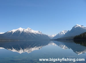
Opened in 1933 during the heart of the Great Depression, the Going to the Sun Road served two purposes: to open the magnificent scenery found in the interior of the park to visitors as well as connecting the eastern (St. Mary) and western (West Glacier/Apgar Village) sides of the park with a seasonal road. The Going to the Sun Road is not a place to come for solitude. During the summer, thousands of vehicles a day make the trip between West Glacier and St. Mary. And between the traffic, the slow speed limit in the alpine section of the drive and the many unexpected stops for sightseeing, a trip along the Going to the Sun Road generally takes a bare minimum of two hours (but definitely allow for more time in your schedule when taking this drive). Beginning in West Glacier, the Going to the Sun Road first passes through a short stretch of forest beyond the admission station, and then reaches a “T” junction at a stop sign. The official “historic landmark” section of the road begins here and heads to the east, toward the mountains. However, those in search of supplies or gifts, or simply want to take in an outstanding view of Lake McDonald, should take the one mile detour to Apgar Village. From the village, an excellent viewing area provides dynamite views of Lake McDonald and the distant mountains. As the Going to the Sun Road travels to the east, it passes along the southern shoreline of Lake McDonald. The road is generally in the trees, but there’s plenty of areas that provide excellent views of the lake and the peaks beyond it. Best of all, though, there are numerous spots to pullover along the road. From these pullouts, it’s generally just a 10 yard hike down to the shoreline of Lake McDonald. Many of these “trails” lead to the beautiful gravel beaches that lie all along the southern shoreline of the lake. From these beaches, the views of Lake McDonald, Mt. Stanton and Heaven’s Peak are outstanding. These beaches are also excellent places to lounge in the sun, have a picnic, or simply pass the time with a good book. After about ten miles, the Going to the Sun Road reaches the historical Lake McDonald Lodge. In addition to the lodge, a gift shop is also available. The parking lot in front of the Lake McDonald lodge also serves as a trailhead for those hiking up to Snyder Lake or to Sperry Chalet. The next five miles of the drive are, relatively speaking, sedate. The drive generally passes through the forest, with several open areas offering excellent views of the ever-larger mountains of the Continental Divide (known as the Garden Wall). Additionally, several pullouts offer some excellent views of McDonald Creek and the towering peaks that abruptly rise from the southern side of the road. The road then reaches Avalanche Lake Campground. This is one of the most popular campgrounds in Glacier National Park. In addition to the short Trail of the Cedars nature trail, the Avalanche Lake Campground is the trailhead for the easy yet beautiful hike to Avalanche Lake. Anyone who can spare two hours in their schedule should absolutely take the two-mile hike to Avalanche Lake, as the views are spectacular. Beyond Avalanche Lake Campground, the road begins closely following McDonald Creek and a few miles later reaches the base of the Continental Divide, turns north and begins to climb steeply. The road soon passes through the West Side Tunnel. On the other side of the tunnel, the road becomes very narrow (so watch out), and rocks overhang the road in many spots. Less than a mile beyond the West Side Tunnel, the Going to the Sun Road makes a 180 degree turn at “The Loop.” A small parking area is located here, and I highly suggest taking time to park and take in the sights as the views of Heaven's Peak are excellent.
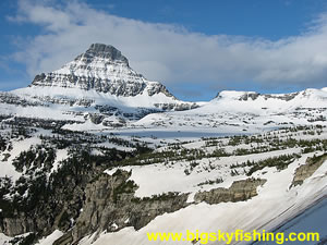
Beyond the Loop, the Going to the Sun Road continues to make its way toward Logan Pass, now visible off in the distance. Between “The Loop” and Logan Pass, the drive clings to the mountainsides. Yet, there’s many places to pull over to take in the views that seemingly just get better and better as the road gains elevation. The road also passes the Weeping Wall, which is essentially a small rock face that “weeps water” during the spring and early summer (by August, the Weeping Wall is usually quite dry). After a twisty, beautiful and sometimes nerve-wracking drive along the mountainside, the Going to the Sun Road reaches Logan Pass, which is where the road crosses the Continental Divide. At Logan Pass, there’s a large parking lot as well as a visitors center. The Logan Pass parking lot serves as a trailhead for two of the most stunning hikes in Glacier National Park: The Highline Trail and the Hidden Lake Trail. When visiting Logan Pass, do remember that parking spots are limited and can be difficult to find during the height of summer between the hours of 11am and about 2pm. After crossing Logan Pass, the Going to the Sun Road starts losing elevation quickly. About a half miles below Logan Pass, the road passes by the “Big Drift.” The “Big Drift,” which is usually one of the last sections of the road cleared during snow-removal operations, is aptly named. During the winter months, the high winds deposit a massive amount of snow in this sheltered spot. It’s not uncommon at all to have a snow depth here during the spring in excess of forty feet (some years there’s been nearly seventy feet of snow!). Because of this, remnants of the “Big Drift” usually linger well into August before completely melting away. See photo of the Big Drift. Just beyond the “Big Drift,” the Going to the Sun Road enters the East Side Tunnel, the longest tunnel in the Park. Instead of just charging down the road, I’d suggest pulling over in one of the many pullout spots, as from here the visitor gets superb views of Mt. Reynolds and the alpine terrain around Logan Pass. A little beyond the East Side Tunnel, the Going to the Sun Road makes a sharp turn at Siyeh Bend. The small parking lot here serves as the trailhead for the Siyeh Bend Trail and the Piegan Pass Trail.
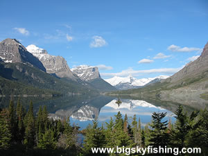
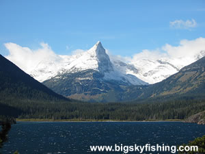
Less than a mile beyond Siyeh Bend, the Going to the Sun Road reaches Jackson Glacier Overlook. Until a few years ago, the views weren’t that great since tall pine trees blocked the view. However, courtesy of some avalanches, some views of the Mt. Jackson and surrounding peaks has really opened up in this area, particularly just below the actual overlook. Additionally, the parking lot at Jackson Glacier Overlook serves as the trailhead for the Gunsight Lake Trail, a rather long hike that leads to the spectacular Gunsight Lake. From the Jackson Glacier Overlook, the Going to the Sun Road continues to lose elevation as it passes through forested terrain. Until reaching the northern shoreline of St. Mary Lake, the views are somewhat limited except in a few spots. Soon, though, the Going to the Sun Road reaches the road that leads to Sun Point, an absolute must-stop. A large parking area and picnic area is located at the end of the short road that leads to Sun Point. A very short nature trail also leads to the shoreline of St. Mary Lake. From this nature trail, the views of St. Mary Lake and the surrounding mountains are superb. In my opinion, this is an absolute “must-see” location in Glacier National Park, so don’t drive right by it! Beyond the Sun Point road junction, the Going to the Sun Road starts twisting along the northern shoreline of St. Mary Lake. The views of the lake are excellent, and many pullouts are available. As the road nears Rising Sun, the Going to the Sun Road passes by what is almost certainly the most photographed location in Glacier National Park, the Wizard Island Overlook. From here, the views of St. Mary Lake, the Continental Divide and the surrounding mountains are truly superb. Parking is very limited at this overlook, so take the first spot you find, even if it means walking an extra block or two. After the Wizard Island Overlook, the Going to the Sun Road flattens out. It soon passes through Rising Sun, which has limited lodging available. And beyond Rising Sun, the road straightens a bit as it passes through more open terrain. The views along this stretch of road are excellent, especially if you’re traveling from east to west. The Going to the Sun Road ends in St. Mary. Before leaving the park, though, the St. Mary Visitor Center is a great place to stop. The visitor center has numerous exhibits, along with a large gift shop. Overall, the Going to the Sun Road is the pre-eminent scenic drive in Montana as far as I’m concerned. At times the traffic might threaten to drive you crazy, but the superb views make any trip along the Going to the Sun Road a worthwhile drive. Additionally, much of the traffic problem can be avoided by visiting Glacier National Park in late June or after Labor Day, or by driving the road later in the afternoon/early evening or soon after sunrise. It’s only during the late-morning, early-afternoon rush during the summer months that traffic is really bad. Quick Facts
|
| Montana Web Cams | Contact | Privacy Statement | About | Photo Use Policy | Advertising Info |

