The Mt. Haggin Scenic Drive
Running between Montana Highway 1 near Anaconda and Montana 43 along the Big Hole River, the Mt. Haggin Scenic Drive is a route all but unknown by out-state visitors. Indeed, except for elk hunters, few Montana natives even know about this scenic gem that begins just a few miles from Interstate 90.
The paved, twenty-two mile Mt. Haggin Scenic Drive follows Highway 569 for its entire length. Admittedly, the northern starting point of the drive isn’t likely to elicit much interest since the drive begins among the mining scars to the east of Anaconda on Highway 1. Additionally, when seen from Highway 1, there is nothing to show what lies further down the road. As such, the Mt. Haggin Scenic Drive has few visitors except those who happen to travel between the Big Hole River and Interstate 90.
The northern starting point for the drive begins just to the east of Anaconda, at the junction with Highway 1 and Highway 569. The first few miles are, shall we say, not exactly thrilling. The road passes through old mining scars that are only now just beginning to recover.
Yet the landscape changes dramatically once the road enters the Mt. Haggin Wildlife Management Area (WMA). Spanning 58,000 acres, the Mt. Haggin WMA is a vast reserve that essentially links the sprawling National Forest lands to the east and west. The reserves primary function is to provide critical habitat for elk and other wildlife, as well as allowing migratory routes unhampered by development.
When traveling from the northern starting point, there isn’t much to see initially once the road enters the WMA, as steep hills and forests blocks most views. However, soon the road begins to climb toward a pass that leads across the Continental Divide, with enough open areas to provide tantalizing hints of what lies ahead.
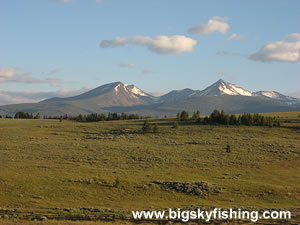
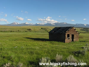
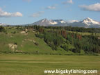
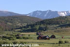
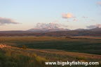
Then the road crests the Continental Divide and the whole landscape opens up as the scenic drive enters the heart of the Mt. Haggin WMA. This portion of the WMA that lies just to the south of the Continental Divide consists of vast, sprawling grasslands with sporadic forests, all of which are surrounded by the snow-capped peaks of the Anaconda Range.
As the road heads south from the pass, the drive lazily curves around the hills and benches that are part of the landscape. Numerous side roads lead off the main highway and are tempting targets to explore. However, for those who truly wish to experience the scenic beauty of this drive, one side-trip is mandatory.
About four miles to the south of a scenic pull-out near an old settlement, a dirt roads (which is only marked by a falling down sign that provides information about the Mt. Haggin WMA) cuts off from the main highway and climbs the “bench” that blocks some of the views from the main highway. Once on top of the “bench,” the views open up in all directions. Beautiful grasslands march toward the sharp, vertical rise of some of the taller peaks of the Anaconda Range.
The road cuts through prime elk habitat. Those who decide to spend the night camped on “top of the bench” as I did are likely to see elk and listen to their bugles throughout the night. Just be sure to bring the mosquito repellant, as the mosquitoes here are terrible during the summer months (as they usually are around the Big Hole River).
Perhaps best of all, the dirt road continues winding its way across the bench for several miles, providing nearly unobstructed views of the vast grasslands and towering mountain peaks.
About ten miles south of the junction with the unnamed dirt road that leads to the top of the bench in the Mt. Haggin WMA, the scenic drive ends at the road junction with Montana Highway 43, which is part of the Big Hole Valley & River Scenic Drive.
Overall, the Mt. Haggin Scenic Drive is a superb drive that anyone passing through Montana on Interstate 90 or Interstate 15 should do. While it’s a bit of a detour to take this route, the scenery is well worth it.
Quick Facts
- Length: 22 miles
- Highlights : Mt. Haggin Wildlife Management Area, Anaconda Range
- Road Type : Paved
- Nearby Towns : Anaconda
- 4wd needed? : No
- Traffic : Light
- Trailers? : Yes
- Season : The highway the drive follows is open year-round. The dirt side roads that lead into the refuge are closed during the winter months to motorized travel.
Map of the Mt. Haggin Scenic Drive
The map below shows the route and location of the Mt. Haggin Scenic Drive in Montana, along with several other nearby scenic drives.

|
Where to Stay & Other Services
There are no services of any kind along the Mt. Haggin Scenic Drive. However, Anaconda is just a few miles from the northern starting point of the drive and has everything needed.
Camping areas are abundant along the drive. Primitive camping is allowed within the Wildlife Management Area, so pick a spot and enjoy. There are no hotels or motels along the route, however.
|
Related Articles & Information
|
|