The Iceberg Lake Trail
.gif)
The Iceberg Lake Trail, as mentioned, begins in the Many Glacier Valley
of Glacier National Park. The Many Glacier Valley is located on the east
side of the Continental Divide, to the north of St. Mary. As this area
is located on the east side, this part of the park can get very windy
at times. It is not uncommon at all to have to fight 40 mile per hour
sustained winds at the base of the mountains, only to find the wind totally
disappear as the hiker nears the Continental Divide.
Reaching the trailhead of the Iceberg Lake Trail is easy - just follow
the Many Glacier Road (the only road that accesses this part of the park),
all the way to its end. From there, the Iceberg Lake Trail makes its
only true “climb” of the entire hike – a short 200
yard moderately steep hike. Once you’ve made it up this short little
climb, take heart, as you’ve just put the hardest and steepest
part of the hike behind you!
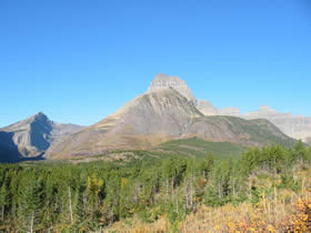
Once on top of this little climb, the Iceberg Lake Trail runs through
open terrain, above Wilbur Creek and the forests that surround it. As
such, you get tremendous views on this lower section of the trail. Mt.
Wilbur rises directly in front of you, while the Ptarmigan Wall makes
its way down the entire western horizon. Mt. Henkel and Atlyn Peak are
also an ever present sight, as it dominates over the hiker – rising
directly above the trail.
After about a mile and a half, the trail begins to enter some scattered
forests, although the view is in no way blocked. Soon there-after, the
hiker arrives at a bridge that crosses Ptarmigan Creek. This is a nice
little creek that runs all year long, fed as it is by Ptarmigan Lake.
The creek marks the halfway point up to Iceberg Lake. And, as such, it
is both a popular rest stop as well as being a convenient place to fill
up any empty canteens or hydration
systems that are running low on water.
Just beyond the Ptarmigan Creek crossing, the Iceberg Lake Trail meets
up with the Ptarmigan Tunnel Trail. This trail leads, rather steeply,
up to beautiful Ptarmigan Lake and beyond, including the unique Ptarmigan
Tunnel.
Beyond the junction with the Ptarmigan Tunnel Trail, the Iceberg Lake
Trail continues very gradually increasing in elevation, makings its way
through scattered forests that frequently open up to provide for some
spectacular views.
The Iceberg Lake Trail continues through scattered forest terrain, very
gradually increasing in elevation, for about another half mile. Then
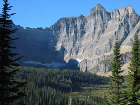
it emerges into the open, wind swept terrain, directly below the Ptarmigan
Wall- which towers far above. The cliffs of the Ptarmigan Wall in this
section are about 2500-3000 feet above the trail – making the hiker
feel rather “insignificant.”
The trail continues to very gradually increase in elevation as it makes
its way towards the lake and far below the summit of the Ptarmigan Wall.
The views in this section of the trail are, quite simply, incredible.
You can look to the east and see both the route you took to get up here
and the whole Many Glacier Area. The Ptarmigan Wall rises directly above
you, while Mt. Wilbur and Iceberg Peak lie directly in front of you – completely
dominating the skyline. Also, this part of the Iceberg Lake Trail is
an excellent place to view bighorn sheep.
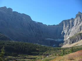
After running for about two miles through this open terrain, the Iceberg
Lake Trail at last begins to approach Iceberg Lake, with a very short,
moderately steep ascent required to reach the highest elevation point
on the hike. From here, it is just a simple and short walk down to the
shores of the lake itself. The cliffs that flank Iceberg Lake are more
than 3000 vertical feet in height – keeping the basin in shadows
for virtually all of the year.
Conclusion
Overall, the Iceberg Lake Trail is a “must do” hike for
anyone who wants to truly see the interior of Glacier National Park but
doesn’t want to carry a heavy pack out on a multiple night backpack.
The views provided by the Iceberg Lake Trail are nearly unrivaled in
Glacier. Couple the awesome views with the excellent wildlife viewing
possibilities available from the trail and you have the makings of a “perfect
hike.”
 Also
View the Iceberg Lake Trail Photo Gallery Also
View the Iceberg Lake Trail Photo Gallery
Hiking Gear & Equipment Guide for Glacier National
Park |
 |
Hiking
Boots : Buyers guide to getting the
right boot for hiking |
Top of Page
|